Up and down the Kennebec Valley: Malta War, 1809
by Mary Grow
There are still some left-over ponds and related information to continue the previous subseries, but your writer is ready to take – and to give her readers – a break from maps, water bodies and genealogies.
Instead, she will present the story of an often-mentioned, but in detail long avoided, historical event, the Malta War. (From 1809 to 1820, the present Town of Windsor was named Malta.)
The origins of this conflict go back to pre-settlement land titles, a complex topic; and the “war” itself has many surviving original documents that a serious historian would consult when attempting to describe it.
Fortunately, this series is not serious history, but history lite, or second-hand history, and earlier writers have done the research that will be summarized below.
* * * * * *
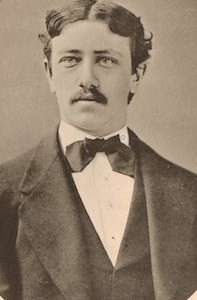
The chapter on Sources of Land Titles in Henry Kingsbury’s Kennebec County History was written by Lendall Titcomb, Esquire. This man was probably the Lendall Titcomb who graduated from Harvard in 1871, was a lawyer like his father and was mayor of Augusta in 1901 and 1902.
Titcomb discussed two types of titles. Some 17th-century settlers obtained deeds from the indigenous inhabitants, who, Titcomb said, occupied and used the land as tenants in common – all were part owners of an undivided tract – and assumed they were merely adding more owners. They therefore saw no problem selling the same piece of land to more than one person.
These deeds and resulting occupation and use of North American land Titcomb considered legally inferior to a title or license from the British monarchy. He did not mention, though other historians did, that the British land titles were created with completely unrealistic boundaries, because nobody in London knew the area they were describing.
After a summary of competing French, Spanish and British claims to North America, Titcomb talked about the 1606 Virginia charter and the 1620 New England Charter, both granted by James I (who ruled England from 1603 to 1625).
The New England Charter covered all the North American territory not “actually possessed” by another European power between the 40th and 48th parallels of latitude – that is, between the latitude of Philadelphia and the latitude of Gander, Newfoundland, north of the United States.
James I awarded the 1620 charter to the 40-man Council of Plymouth. This Council, in 1629, granted what Titcomb said was the “Kennebeck or Plymouth Patent” to “the Pilgrim colony.”
The 1.5 million acres covered 15 miles on each side of the Kennebec River from the north boundaries of Topsham and Woolwich upriver to the junction with the Wesserunsett, close to Skowhegan.
In October 1661, Titcomb wrote, the Plymouth Council sold the whole parcel to four men from Boston. These new owners paid little attention to their holdings; not until August 1749 did interest revive.
By then, Titcomb pointed out, inheritances had added many new owners who “were widely scattered, and knew very little of the extent or value of their lands.” After a series of meetings, in June 1753, the owners formed a new Boston-based corporation that was formally “The Proprietors of the Kennebec Purchase from the late Colony of New Plymouth,” or informally either “the Kennebec Company” or “the Plymouth Company.”
In 1761, this corporation hired a surveyor named Nathan Winslow to divide into lots the land on both sides of the Kennebec River between (current) Chelsea and Vassalboro.
An on-line Winslow genealogy says Nathan was born April 1, 1713, in Freetown, Massachusetts, and died Nov. 22, 1772, in Falmouth, Maine. His parents were James and Elizabeth (Carpenter) Winslow, married in 1708. The family were Quakers, and James was the first of the family to move to Maine, getting a land grant and building a mill in Falmouth.
The lots Winslow created had very little river frontage compared to their depth – modern records would call them “spaghetti lots.” Alma Pierce Robbins, in her Vassalboro history, said the Proprietors had voted to have them 50 rods (about 825 feet, or one-fifteenth of a mile) wide and a mile deep.
Beyond the riverfront lots, Winslow laid out a rangeway eight rods wide; then a second tier of long narrow lots; another rangeway; and a third tier of lots. Some lots the Proprietors reserved for themselves; the majority they sold to people wanting to settle in the Kennebec Valley.
By 1766, Titcomb wrote, most of the lots were sold. Because the terms of sale required each new resident to build a house and start farming within three years and stay – or will or sell to a successor – another seven years, they were occupied as well.
In January 1816, Titcomb said, the current Proprietors sold all the unsold bits and pieces, like gores (triangular bits of land where survey lines didn’t quite match) and islands, to a man named Thomas L. Winthrop. He later sold to residents.
This description sounds like a logical plan to create an inhabited region. In practice, though, large areas were left vacant, and people without legally recognized titles began to fill them.
Linwood Lowden, in his Windsor history, said settlers who were unaware of, or deliberately ignored, the Proprietors’ rights began moving into the Windsor area before the Revolution. More came after the war, “settling for the most part wherever their fancy struck.”
A resident named Ebenezer Grover had surveyor Josiah Jones lot out 6,000 acres in Windsor in 1797, Lowden wrote. Grover and others sold lots, many to speculators who resold them. Grover had no legal title to the land he sold, and he knew it: Lowden wrote that some deeds said explicitly the sellers would not defend buyers against claims by the Proprietors.
The Proprietors did make claims, filing lawsuits to evict the squatters. They also recruited agents among the settlers to keep them informed of sales. From 1802 on, they hired surveyors to resurvey parts of Windsor and offered to sell the new lots to the people already living on them.
The squatters, who had paid for their land and were mostly cash-poor as they tried to make a living from it, felt they were being unfairly made to pay again. And, Lowden wrote, when they were hauled into court, they found the judges were often Proprietors or their agents.
Young men in Windsor organized to harass and intimidate the surveyors. Two of the group were Elijah Barton, mentioned last week, and – probably – Paul Chadwick. They drove at least one of the Proprietors’ spies out of town (Lowden quoted his appeal for help to the Massachusetts General Court).
On Sept. 8, 1809, according to Lowden’s description, Isaac Davis was surveying on Windsor Neck, the northeastern part of town, for a resident named Aaron Choate, who planned to re-buy his property from the Proprietors. Davis’s chain men were two settlers’ sons, Jones or Jonas Pratt and Paul Chadwick.
Lowden surmised that the anti-Proprietors saw Chadwick as a turncoat. Nine of them disguised and armed themselves and went after Davis and his team, especially naming Chadwick.
Lowden said some were wrapped in blankets like Indians, and all wore caps and masks, or “veils.” James North, in his Augusta history, described the “conelike” multi-colored peaked caps, from which the veils fell over the men’s faces, with holes for eyes and mouth.
At least three men had guns, specified as pistols in North’s telling. The rest were armed with what Lowden called “the pointed ends of old scythes fastened into pine handles.”
The “Indians” found Choate first. They waited until the surveyors came out of the woods to join him, Chadwick leading. One (Lowden) or several simultaneously (North) shot Chadwick, who died two days later.
The suspects were identified, some by Choate and the dying Chadwick, and arrested. Brought before a magistrate on Sept. 15, they admitted they were there when Chadwick was shot. They were jailed in Augusta to await indictment and trial.
In the interval, as described by Lowden and in more detail by North, their supporters began to fear harsh penalties and to plan a rescue. Word reached the authorities in Augusta of armed men preparing to free the prisoners, “burn the county buildings” and destroy Proprietors’ and agents’ houses.
During the earlier years of unrest, Augusta resident had organized the “Augusta Patrol,” described by North as a 28-man group who took turns patrolling the town overnight. Now, precautions increased.
Augusta officials put a cannon on the west end of the Kennebec bridge and enlarged the nightly patrols. The night of Sept. 29, North wrote, there was a false alarm that kept everyone up all night. Around midnight on Oct. 3, some 70 men actually did approach the bridge and get into a fight with its defenders (apparently without casualties).
“Alarm guns were fired, the court house bell was rung, the Light Infantry turned out, the streets were filled with people and a general uproar ensured,” North said.
In the next few hours, Augusta officials called several hundred armed men (these were organized military companies; North does not use the word “militia”) from neighboring towns to defend the jail and repel the expected attack. A field piece was borrowed from the Hallowell artillery unit, and sentinels were posted throughout Augusta.
In following days, temporary barracks were built to accommodate the out-of-town regiments, and sentry boxes for the sentries. Augusta “assumed the appearance of a military post during actual war,” North wrote.
The Supreme Court’s October term began Oct. 3. The grand jury indicted the nine men for murder and set their trial for Nov. 16. In the intervening weeks, the number of armed companies was reduced to two, with nearby towns contributing in weekly rotation.
North described the well-attended eight-day trial in some detail. Four judges presided, and, in North’s opinion, Judge Isaac Parker’s summing-up “apparently left no escape for the prisoners.”
But, North wrote, the long trial and masses of information and argument “were too much for the feebly discriminating powers of a jury formed after challenging peremptorily the most intelligent men who were called.” (The challenges he referred to were by the defense.)
After their first long deliberation, jurors asked whether they could give verdicts on some but not all of the defendants. When the judges said no, jurors deliberated another two days before acquitting everyone.
* * * * * *
Lowden listed several consequences of the “Malta War.”
One was an 1810 Massachusetts law specifically applying to anyone who disguised himself as an Indian, “or in any other manner,” with the intent of obstructing people, including surveyors, as they were carrying out laws. Such offenders “shall be liable to indictment in the Supreme Judicial Court” and, if convicted, fined and jailed.
Another consequence was the Proprietors’ February 1811 grant of a lot on the west side of the Sheepscot River to Lois Chadwick, “an infant child,” daughter of Paul Chadwick and his (unnamed) widow, because her mother and grandparents were poor and her father died in the Proprietors’ service.
In 1813, Lowden wrote, a Massachusetts commission recommended, and the General Court approved, a deal under which settlers were given “all disputed lands” in the Kennebec Proprietors’ grant, and the Proprietors were given “the township of Saboomook” instead.
(Saboomook was probably what is now the unorganized territory of Seboomook Lake in Somerset County. Wikipedia says its area is 1,435 square miles; its population in 2020 was 23.)
Main sources
Kingsbury, Henry D., ed., Illustrated History of Kennebec County Maine 1625-1892 (1892)
Lowden, Linwood H., good Land & fine Contrey but Poor roads a history of Windsor, Maine (1993)
North, James W., The History of Augusta (1870)
Websites, miscellaneous
Responsible journalism is hard work!
It is also expensive!
If you enjoy reading The Town Line and the good news we bring you each week, would you consider a donation to help us continue the work we’re doing?
The Town Line is a 501(c)(3) nonprofit private foundation, and all donations are tax deductible under the Internal Revenue Service code.
To help, please visit our online donation page or mail a check payable to The Town Line, PO Box 89, South China, ME 04358. Your contribution is appreciated!


Leave a Reply
Want to join the discussion?Feel free to contribute!