Up and down the Kennebec Valley: Waterville
by Mary Grow
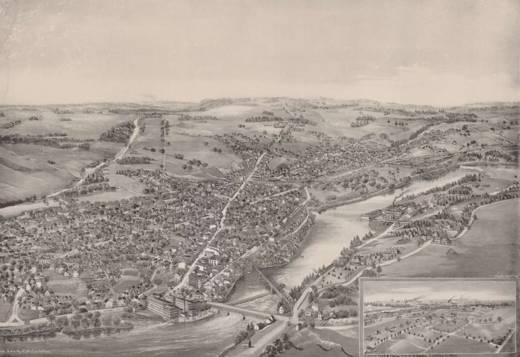
Waterville, now a city, started as the part of Winslow on the west bank of the Kennebec River.
In the 1902 centennial history, editor and writer Edwin Carey Whittemore traced Winslow/ Waterville’s origin from Native American settlements onward.
He wrote that the territory of the local Kennebec (or Canabis, or other spellings) tribe extended from the Atlantic at Merrymeeting Bay up the river to Moosehead Lake, with related inland areas.
One of several Indian villages on the river was in present-day Winslow on what Whittemore called Fort Hill, the high land on the north side of the Sebasticook River as it flows into the Kennebec. This village, Whittemore said, covered “nearly a mile” along the two rivers and had by 1902 had already been explored for Native relics.
There was a small Native burying ground farther upriver, Whittemore said. On the west (now Waterville) bank, there was no evidence of a village, but a large cemetery ran “from what is now Temple street to the site of the Lockwood Mills” at the foot of present-day Main Street (two long city blocks).
Whittemore described some of the corpses found as foundations were excavated for city buildings. He surmised this burial ground served the village across the river.
The falls in the Kennebec, the village on the east bank and the nearby area on both banks were called Teconnet or Ticonic (or other spellings). Native inhabitants interacted with early Europeans – as summarized in the June 6 article on Winslow’s early days, traders beginning in the mid-1600s, followed by soldiers manning Fort Halifax, built in 1754.
Stephen Plocher, in a history of Waterville found on line, and Henry Kingsbury, in his 1892 Kennebec County history, say the early trading posts were on the west bank of the Kennebec, across the river from the Native village.
Plocher wrote that Richard Hammond should be “considered Waterville’s first white resident”; his “trading house on the west side of the river” was operating in 1660. Aaron Plaisted, in his chapter on early settlers in Whittemore’s history, agreed. He wrote that Hammond was “the first white man known to have any connection with the West Side” in his 1660 trading house.
Kingsbury, however, wrote that the Clark (or Clarke) and Lake trading post, which he dated from 1650, was on the Waterville side of the river. And Plaisted continued the sentence quoted above with the statement that Clark and Lake “had a trading house in this vicinity seven years earlier [than 1660].”
Whittemore implied the same location when he quoted from an account of the wars between Natives and settlers that the 1692 burning of “the fort and settlement at Teconnet” ended “the history of earliest Waterville the metropolis of the Canibas [Kennebec] Indians.”
Plaisted wrote that from the mid-1600s to the mid-1750s, there is no information on Europeans in the area. In 1754, he said, “there were no settlers.”
Building a fort enticed a few brave men to buy from the Plymouth Company (or perhaps a Native chief), or to claim a homestead without legal formalities. The end of the wars with French-supported Natives in 1763 let settlers feel safe moving farther away from the fort.
The west side of the river was called either West Side or Ticonic, according to Plaisted. Another source suggested the west side might have been called West Winslow at some point, though he gave neither date nor evidence.
The settlement on both sides of the river became a plantation named Kingfield or Kingsfield (your writer found neither an explanation for the name nor a date for the plantation). On April 26, 1771, the plantation was incorporated as the Town of Winslow, named for Massachusetts General John Winslow, who had supervised the building of Fort Halifax.
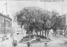
Located in the heart of the historic downtown district, Castonguay Square is one of Waterville’s oldest public gathering spaces. Gifted to the city by land deed in 1840, “The Commons” was renamed Castonguay Square in 1921 for Arthur L. Castonguay, the first soldier from Waterville to be killed in action in World War I.
Plaisted said Dr. John McKechnie surveyed parts of both sides of the river “from Winslow to Hallowell” and was an early settler on a west-side lot that ran from the Kennebec west to Messalonskee Stream.
(Messalonskee Stream is the outlet of Messalonskee Lake, aka Snow Pond, which is shared between Sidney, the town south of Waterville, and Belgrade, west of Sidney. The stream leaves the north end of the lake, goes north through Oakland, west of Waterville, and turns east and south through Waterville to join the Kennebec.)
Plaisted named several men living in Waterville by 1770. In addition to McKechnie, they included Ebenezer Bacon, on a large farm by the river in the north end, close to the Fairfield line; and William Brooks at the north end of the present downtown business district, who “probably built the first of several houses erected on that site.” More families owned riverside property farther south, to the town line.
Whittaker found that voters at a May 1772, town meeting accepted “the road which is now Main street and College avenue,” the main artery on the west bank from contemporary Fairfield south – past Bacon’s farm and Brooks’ house — through contemporary Waterville.
Plaisted and Kingsbury said Winslow’s west-side population quickly outgrew the east-side population. Kingsbury cited three pieces of evidence: the west side got the first doctors, “who always choose the most central point”; there were “very early” mills on Messalonskee Stream; and the majority of names in early “civil or business records” were “clearly westsiders.”
The 1790 census showed 779 Winslow residents; Plaisted and Kingsbury agreed that only about 300 lived on the east side. Kingsbury listed by name more than 60 men who “lived and paid taxes” in future Waterville in 1791. Plaisted went on to postulate that by 1802 the west side “probably” had about 800 inhabitants, out of 1,250.
The historians said the mills on Messalonskee Stream, which was smaller and easier to dam than the Kennebec, were one reason for west-side growth. In 1792, Plaisted said, Asa Redington and Nehemiah Getchell built the first dam across the Kennebec at Waterville, sharing the cost with Dr. McKechnie’s heirs.
There was no bridge connecting the two sections of Winslow, and no historian your writer has found talked about ferries or other regular connections. The Quakers who lived in North Fairfield (west bank) and worshipped downriver in Vassalboro (east bank) crossed the Kennebec and the Sebasticook by fords, locations unknown.
Ernest Marriner, in Kennebec Yesterdays, listed 18th-century ferries in Fairfield, Vassalboro and Augusta and the 1797 Augusta bridge. “For some unaccountable reason,” he wrote, the Kennebec was not bridged at Waterville until 1824.
Whittemore said the first vote to make the west side a separate town was in 1791. It carried, 13 to seven, but was not implemented, Whittemore suggested because so few men voted.
Instead, for some years town offices had two incumbents, one for each side of the river, and town meetings alternated from one village to the other. There were repeated discussions of a division, usually with the Kennebec as the boundary.
Whittemore mentioned one proposal for a town line “one mile west of the river.” And Plaisted said a 1795 petition to the Massachusetts legislature proposed the name Williamsburgh – perhaps, he suggested in honor of Dr. Obadiah Williams, another early resident.
Whittemore summarized, “The expedient of holding town meetings alternately on the east and on the west side of the river was not satisfactory. Two collectors and a double set of town officials did not conduce to harmony.”
The division of Lincoln County to create Kennebec County, effective Feb. 20, 1799, might have given impetus to the division of Winslow.
On Dec. 28, 1801, Winslow voters sent the Massachusetts legislature a petition to turn the west bank settlement into a separate town named Waterville. The main reason for division they cited was the difficulty of crossing the river “in several parts of the year,” especially spring, to attend a religious or town meeting on the other side.
The Massachusetts legislature approved the incorporation of Waterville on June 23, 1802. There is no record of who chose the name or what he or they had in mind.
One suggestion is the obvious: lots of water, with the Kennebec River and Messalonskee Stream. Historian Ernest Marriner suggested the name was selected to avoid displeasing any of several prominent men who wanted the town to bear their names.
Kingsbury and Plaisted would have preferred the name “Ticonic.” Kingsbury called the Native name “more liquid and flowing” than the white man’s choice. Plaisted wrote that it had a “flavor” that the hybrid French-English “Waterville” lacked.
Plocher, on the other hand, found the choice appropriate – perhaps prophetic – in view of the role French-speaking Canadians played in Waterville’s later growth.
By 1802 only one of the three selectmen was an east-side resident; he was authorized to call the next Winslow town meeting, while Waterville would hold its initial meeting on the west bank. This meeting was held Monday, July 26, 1802, and elected a long list of town officials (including Ebenezer Bacon as one of Waterville’s first three selectmen).
(Confusingly, Whittemore wrote this town meeting was held in the East meeting house. He did not mean east of the Kennebec: later, he says the second meeting, Aug. 9, 1802, was in the west or Oakland meeting house, that is, in western Waterville. The east meeting house was in current downtown Waterville between Main Street and the river, near the present Waterville City Hall.)
Plocher summarized another major change in this west-side town: its west side, too, developed as an independent center, with numerous manufacturers using Messalonskee Stream’s water power. An Oakland website says by 1850, there were four dams on the half-mile of stream below the lake’s outlet; it quotes a man who described the stream as “lined with factories.”
This source credits these manufacturers, “unhappy about taxation,” with proposing a separate town named West Waterville, incorporated by the Maine legislature on Feb. 26, 1873.
Local voters changed the name to Oakland in 1883, Plocher says “to establish a more distinct identity.” Mapquest on-line says the name was “presumably” chosen because of “all the oak trees in the town, though some favored the name Weldon” (for which Mapquest offers no explanation).
The remainder of Waterville was incorporated as a city early in 1888. An on-line source says on Jan. 12. Whittemore wrote: “Waterville began her career as a city by the acceptance, January 23, 1888, of the amended city charter, which had been granted by the Maine Legislature, March 4, 1887.” The charter is reproduced in his history; it says it is amending a Feb. 23, 1883, charter.
The vote to accept the charter, Whittemore said, was 543 to 432. He did not explain whether the opponents objected to the idea of a city or to specific provisions in the charter.
Main sources
Kingsbury, Henry D., ed., Illustrated History of Kennebec County Maine 1625-1892 (1892).
Plocher, Stephen, Colby College Class of 2007, A Short History of Waterville, Maine Found on the web at Waterville-maine.gov.
Whittemore, Rev. Edwin Carey, Centennial History of Waterville 1802-1902 (1902).
Websites, miscellaneous.
Responsible journalism is hard work!
It is also expensive!
If you enjoy reading The Town Line and the good news we bring you each week, would you consider a donation to help us continue the work we’re doing?
The Town Line is a 501(c)(3) nonprofit private foundation, and all donations are tax deductible under the Internal Revenue Service code.
To help, please visit our online donation page or mail a check payable to The Town Line, PO Box 89, South China, ME 04358. Your contribution is appreciated!


Leave a Reply
Want to join the discussion?Feel free to contribute!