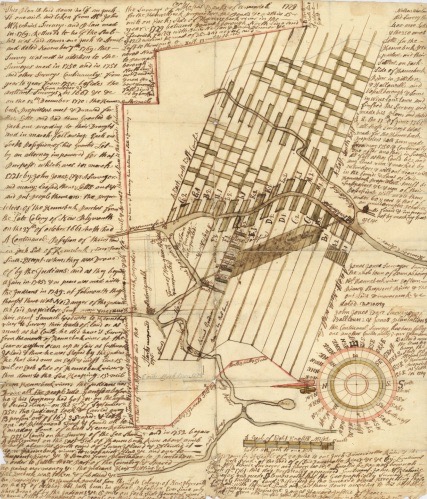
Manuscript map 41, which is a copy of a plan of “Great Lotts in the fifth division along the Kennebec River” from the Plymouth Company collection, was taken from surveys made by John McKechnie and John Jones. Contributed to Maine Memory Network by Maine Historical Society Date: March 1771
Another Kennebec Valley surveyor who worked for the Kennebec/Plymouth Proprietors/Company was Dr. John McKechnie (1730 or 1732 – April 14, 1782).
Ernest Marriner, in his Kennebec Yesterdays, called McKechnie “one of those men of varied talents who meant so much to many pioneer communities” – “an educated physician, a civil engineer, a land surveyor, and a shrewd business entrepreneur.”
McKechnie was a Scotsman who came to America in 1755 and to Winslow in 1771. On July 26, 1755, as he left Scotland for Boston, he started a diary that became the source for at least two biographical sketches, one by Aaron Plaisted in his chapter on early settlers in Edwin Carey Whittemore’s history of Waterville and one in a medical directory found on line.
The latter, an article in the May, 1917, issue of the Canadian Medical Association Journal, says McKechnie was born about 1730 and got a medical degree or license in 1752 from either Edinburgh or Aberdeen. After three years’ practicing in his native land, apparently without marked success, he left Greenock, Scotland, by ship at 4 p.m., July 26, 1755, and landed on Boston’s Long Wharf at 7 p.m., September 12, 1755.
In the Boston area, he tried practicing medicine, and teaching (unspecified). On May 15, 1760, he “became an official of the Plymouth Land Company with the rank of Lieutenant and the position of a land surveyor.” The medical journal article says he stayed with the company for four years, surveying in the Kennebec and Penobscot river valleys.
By 1760, McKechnie was teaching in Pemaquid, Maine, where he met and married Mary North (1742 -1816), daughter of the Captain North who was in charge of the fort at Pemaquid. Plaisted dated their wedding Jan. 1.
The medical journal’s biography says Captain North “officiated at the wedding, although he is said not to have favored the match, either because Dr. McKechnie was too old, or had no settled profession.”
(If this “Captain North” is the Captain John North who is listed on FamilySearch as Mary North’s father, he was born in 1698 and married either Elizabeth Lewis, born in 1714, or Elisabeth Pitson, born in 1719. FamilySearch names each on different pages, plus a “Miss Burton” whom John North supposedly married in 1720.)
The medical biography mentions McKechnie practicing medicine in Pownalborough; treating a smallpox case on Swan’s Island; and from 1764 to 1771 practicing in Bowdoinham. Marriner found him named as a Bowdoinham selectman in 1764.
In 1771 the family moved to Winslow, and in 1775, they moved across the river, to what became Waterville in June 1802. Plaisted and Henry Kingsbury, in his 1892 Kennebec County history, said McKechnie was a Winslow selectman from 1774 through 1777.
Plaisted said when McKechnie moved to the west side of the Kennebec, he settled on Messalonskee Stream “near the Crommett bridge” at the place still known in 1902 as Crommett’s Mills. He built a log cabin and the first dam and sawmill on the stream; Kingsbury said he also had a grist mill.
(Crommett’s Mills was the part of Waterville where Messalonskee Stream, running south on its way to the Kennebec, loops northeast before returning to its original direction. Western Avenue now runs east-west across the top of the loop; Crommett Street is one of the streets intersecting Western Avenue from the north.)
The medical biography added that in his cabin, McKechnie “partitioned off a room for a dispensary of the drugs which were so extensively dealt out to sick people in that era.” This source says his medical practice “increased with considerable rapidity”; other historians say it was less important than his surveying.
The medical biography says he invested some of his income in timberlands to feed his sawmill. In 1779, he built a new and larger house, perhaps the one Marriner said was the first two-story house in Waterville, “near the present corner of Main and Silver streets.” (Since Waterville’s Concourse was created in the 1970s, these streets no longer intersect.)
Plaisted said of him, “Not one of the early settlers was more active and useful and entitled to respectful memory than Dr. John McKechnie.”
Frederick Thayer, in his chapter on doctors in Whittemore’s history, wrote that “Besides attending to his medical duties he was an active civil engineer and business man. Many of his original surveys are still [1902] extant.”
The sawmill was the only specific business interest mentioned. The medical biography called McKechnie “a man of means” who was able to lend other man $1,000.
This source says during the Revolution, McKechnie was known to lack sympathy for the rebels and was watched by the local Sons of Liberty. Despite his wealth, he was not asked to contribute to a fund to provide ammunition for local volunteers.
However, Marriner and others say he treated members of Benedict Arnold’s 1775 expedition to Québec via the Kennebec. And Marriner quoted McKechnie’s advice to neighbors about selling supplies to Arnold’s expedition: give them “enough, but not too much.”
* * * * * *
Gordon Kershaw, in his book on the Kennebec Proprietors, identified McKechnie as the Proprietors’ surveyor in his chapter on the dispute over “Masts for the King’s Navy.” These were the enormous white pines that provided masts for British ships.
Kershaw explained that John Wentworth, Governor of New Hampshire from the summer of 1766 until the American Revolution, was also Surveyor-General of the King’s Woods, a job that he believed included protecting the valuable trees.
When the Kennebec Proprietors began cutting white pines on their land, they started a long dispute with the governor that involved multiple lawsuits. It was never resolved, but was ended in 1775: as the Revolution began, local committees of safety made it clear that no more trees would be sent to the Royal Navy.
James North, in his history of Augusta, mentioned McKechnie’s November 1762, survey of “back land” lots, 10 miles in one dimension and varying in the other, that was the basis of grants to Proprietors. North quoted that the land was given to these men “in consideration of their great trouble and expense in bringing forward settlements on Kennebec River.”
Kingsbury wrote that McKechnie did the first survey of the area that became the Town of Winslow, after the Kennebec Proprietors granted the entire township, on March 12, 1766, to “Gamaliel Bradford, of Duxborough, James Otis, of Barnstable, John Winslow, of Marshfield, Daniel Howard, of Bridgewater, James Warren, of Plymouth, and William Taylor, of Boston Esquires, and to their heirs and assigns forever.”
An undated (maybe 1766?) plan in Kingsbury’s history, labeled Survey by John McKechnie, shows a standard layout along the east bank of the Kennebec south of the junction with the Sebasticook River.
Fifteen narrow (100-rod by one mile?) lots are laid out along the river, all but one with a settler’s name. Inland, south of Pattee Pond, are six much larger lots, both wider and longer, each with the name of one of the grantees. Additionally, on the southeast shore of the pond Winslow has 209 acres; Otis has 168 acres; and Warren has 81 acres.
A rectangular area farther inland has three rows of lots along the tract’s eastern border, numbered from 1 (on the northeast corner, northern lot in the easternmost row) to 95 (on the southwest corner, western lot on the south line). Each lot appears smaller than Warren’s 81 acres.
North of the Sebasticook’s junction with the Kennebec and east of Pattee Pond, McKechnie laid out lots only along part of the east bank of the Sebasticook, to the north boundary. The area between the two rivers, now the center of Winslow, is blank.
Whittemore’s collection of historic documents includes a 1771 deed to land in Waterville that references an October 1770 plan McKechnie made on the west side of the river.
About this plan, Marriner wrote: “Although Dr. McKechnie ran surveys as far down the river as Merrymeeting Bay and as far up as Skowhegan, it was his detailed and carefully mapped survey of both sides of Kennebec for some distance both north and south of Ticonic Falls [between Waterville and Winslow] that makes his name memorable in any consideration of the land titles.”
McKechnie’s 1770 plan has been affirmed in multiple court decisions, Marriner said. He cited one dispute, in an unnamed town in the 1860s and 1870s, in which a landowner spent more than $15,000 and lost six court cases in a failed effort to get one of his McKechnie-drawn boundary lines moved.
Whittemore described another McKechnie project in Winslow. On March 2, 1772, he wrote, Winslow officials “employed” McKechnie to ask Sylvester Gardiner (a Kennebec Proprietor) for land for a cemetery and a road.
The cemetery became “the old cemetery on Fort Hill” on Winslow’s Halifax Street (see Kit Alexander’s story in the Jan. 20, 2022, issue of The Town Line for a modern account of this historic graveyard). The road became Main Street and College Avenue, main arteries on the west (Waterville) bank.
* * * * * *
Plaisted said John and Mary McKechnie had 13 children. FamilySearch lists eight daughters and six sons, the first 13 born between 1760 and 1781 and a daughter born in 1796, named Lydia. Other sources say Lydia was born in 1777.
Kingsbury wrote that three of the McKechnie children were born in the family’s first Waterville house and one more, whom he called the last, in 1781 in the 1779 house.
Among descendants in the area in 1902, Plaisted said a grandson named Erastus McKechnie was living on a farm “on the road to Oakland” that the family had owned since 1801.
Whittemore told this story: “Early in 1773 the authorities of Hallowell (Augusta) sent five men in a boat to Boothbay to carry to the town the Rev. John Murray who was the first minister to be hired by that town. He proceeded to Winslow and Waterville and July 3, 1773, baptised three children of Dr. John McKechnie. This is the first baptism in town of which we have record.”
McKechnie died in 1782, Kingsbury said in his 1779 house. He was buried, with more than three dozen other early residents (including his son, Obadiah, according to Thayer; Kingsbury listed Obadiah as Simon Tozer’s son), in a no-longer existing cemetery on the south side of Western Avenue “on the rising ground a little east of the bridge over the Messalonskee.”
Kingsbury wrote that after McKechnie died, Mary married David Pattee, identified by Plaisted as builder of the second mill at Crommett’s Mills. Mary died July 21, 1816, according to FamilySearch; Kingsbury said she, too, was buried in the old cemetery.
Roland Hallee, editor of The Town Line, says Waterville used to have “a cemetery south of Western Ave., east of Messalonskee Stream, on South St., at the end of the street where the water district used to be. There also was a mill near there (only the foundation remains).”
Main sources
Kershaw, Gordon E., The Kennebeck Proprietors 1749-1775 (1975)
Kingsbury, Henry D., ed., Illustrated History of Kennebec County Maine 1625-1892 (1892)
Marriner, Ernest, Kennebec Yesterdays (1954)
North James W, The History of Augusta (1870)
Whittemore, Rev. Edwin Carey, Centennial History of Waterville 1802-1902 (1902)
Websites, miscellaneous.
Responsible journalism is hard work!
It is also expensive!
If you enjoy reading The Town Line and the good news we bring you each week, would you consider a donation to help us continue the work we’re doing?
The Town Line is a 501(c)(3) nonprofit private foundation, and all donations are tax deductible under the Internal Revenue Service code.
To help, please visit our online donation page or mail a check payable to The Town Line, PO Box 89, South China, ME 04358. Your contribution is appreciated!
https://townline.org/wp-content/uploads/2016/06/TownLineBanner.jpg00Mary Growhttps://townline.org/wp-content/uploads/2016/06/TownLineBanner.jpgMary Grow2025-07-16 15:23:342025-07-16 15:28:21Up and Down the Kennebec Valley: Early surveyors – John McKechnie
0replies
Leave a Reply
Want to join the discussion? Feel free to contribute!


Leave a Reply
Want to join the discussion?Feel free to contribute!