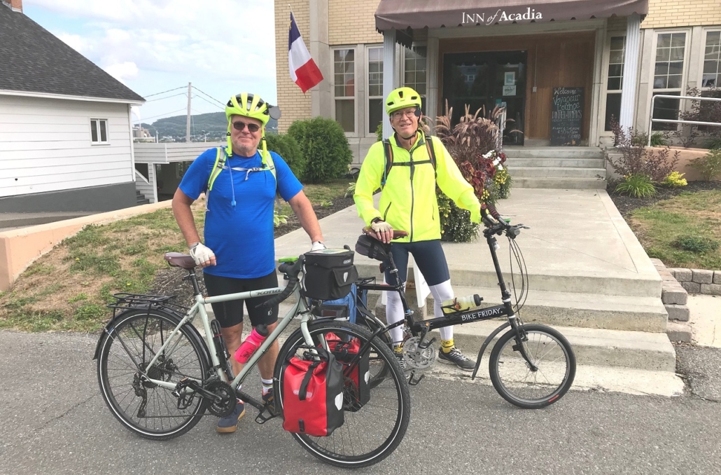
Steve Ball, left, and John Benziger, prepare to begin their journey as they depart the Inn at Acadia, in Madawaska. (photo courtesy of Steve Ball)
fter plans to cycle across the U.S., from Maine to Washington, were scrapped because of the COVID-19 pandemic, John Benziger and I decided to stay in Maine and tackle a safer, Maine challenge: riding our bicycles from Madawaska to Kittery.
As an introduction, Benziger and I have been riding in the local area regularly for some time. We ride through China, Windsor, Vassalboro, Jefferson, Whitefield, Albion, and bordering towns, hugging the shoulders of the roads and dressed in our yellow safety gear. You may have seen us and the many other riders who are increasingly populating the roads. The long-distance travel limitations presented by the pandemic only intensified the itch to get out locally more often.
We arrived in Madawaska in the mid-afternoon of August 16. What a wonderful town. It lies comfortably along the St. John River and overlooks Edmundston, New Brunswick, Canada. The streets are wide, either to accommodate the snow plowed from the streets or wood mill traffic running in and out of town. Everyone we met was charming and happy to greet us, even as we were all peering over our masks. We had a fortunate accidental run-in with Judy Paradis, Madawaska’s long-serving legislator to the State House and Senate. She educated us on the Acadian spirit that runs deep within the people of the region. It was from her that we learned that nuns from France played a big role in settling Madawaska and that the town of St. Agatha is only pronounced one way, and that is “Saint Agatt”.
Our trip started early Monday morning, riding south on Rte.1 with every intention to make it to Caribou. I had heard that Aroostook County was hilly, but I was beginning to doubt the description as we rode south along the St. John River Valley. It was a very scenic and relatively easy ride until we hit Van Buren and took a right headed toward Caribou. Leaving the St. John River Valley we headed inland and abruptly upland, ascending the hills we had heard so much about.
The scenery was breathtaking, though I wasn’t so sure if my breath was taken away by the terrific, colorful and expansive views of agriculture and nature, or by the nearly constant extreme elevation gain we were trying determinedly to overcome. In either case, we conquered the hills and enjoyed every bit of Aroostook County’s natural beauty. We made it to Caribou and Russell’s Motel as planned.
I must add here that time and again throughout the journey we were impressed with the effort and cleanliness of each hotel or motel we stayed in. To run a hotel, inn or motel in these difficult and uncertain times is almost mind-bogglingly difficult; yet at each establishment in which we stopped, the owners or managers appeared intent on doing what they could to make our stay with them safe. We felt as safe as we could expect to feel given the circumstances.

John Benziger, left, and Steve Ball, take a break along the St. John River, during their trek. (photo courtesy of Steve Ball)
We woke up to a downpour on Tuesday, our second day. We had no reasonable alternative but to head out and ride. We headed for Presque Isle with hopes the rain would let up as we moved south. By the time we hit Presque Isle there was no sign of the rain easing up so we stopped for an extended breakfast and drying out in the Governor’s Restaurant, on Main Street. We were able to get our bikes somewhat out of the rain and enjoyed a nice meal and warm hospitality.
On our way to Mars Hill we enjoyed riding through our solar system. In a mock-up put together by the University of Maine at Presque Isle, the planets are arranged along Rte. 1 in distances relative to the actual distance from each other in space. For instance, the Sun is in Presque Isle, the Earth is about one mile from the sun and Pluto is in Houlton, over 40 miles away. If you have not traveled on this part of Rte. 1, I recommend it. It would be fascinating for anyone interested in astronomy, space and the planets.
Our first real glitch occurred waking up in Houlton to news that there was a COVID-19 outbreak in Millinocket. This was not anything we had planned for and, since our next night’s reservation was in East Millinocket, we were in for an interesting day. We needed to change our plans, but where does one stay in this part of Maine? We needed to ride on and try to arrange for a new reservation somewhere a safe distance from Millinocket. During our periodic stops, we were unable to access the internet on our phones. There apparently is not a robust cell tower network in such towns as Smyrna Mills, Island Falls, or Monarda along Rte. 2. We had success in Mattawamkeag! It was late in the afternoon when we finally were able to search for available rooms. We found a room in Lincoln. The added distance from our original plan was a bit of a challenge, but well worth the effort. After 81 miles we arrived at a safe and warm room in the White Tail Inn, in downtown Lincoln.
Our next day’s ride was shortened given our added distance the day before, and we were not unhappy with that. We arrived in Orono about midday and relaxed in our room in the University Inn. We had time to do a very necessary load of laundry and rest our legs and bikes.
The following morning we met Bob Bennett, a friend and local China-area rider, with his bike. Bennett joined us for our ride to Belfast. We rode through Bangor and followed the Penobscot River down to Stockton Springs and Rte. 1. Whew, the extreme hills were behind us and from here on out we would generally hug the coast all the way to Kittery. Bennett departed from us in Belfast and headed for home.
We headed south on Rte. 1. If the usual number of summer vacationers had been driving the famed tourist route, our ride from Belfast to Brunswick might have been more challenging. John Williams, a dear friend and avid cyclist, joined us for this leg of the journey. It was a wonderful ride with very nice late-summer weather and wonderful views of coastal Maine.

Steve and John approach their destination as they peddle along Rte. 1, near Old Orchard Beach. (photo courtesy of Steve Ball)
After a good night’s sleep we headed for Portland. It was not a terribly long ride, roughly 30 miles. This was going to be a particularly good day as we were meeting up with our wives, Mary and Allane, to spend the night together before we headed for our last day of the trip. The wives had arranged for a room and we were looking forward to a comfortable meal together and a relaxing evening.
The last day of the journey was exceptional. We departed Portland fairly early to make sure we arrived in Kittery with enough time to have a good meal, pack up and get ready to head back home. We left Rte. 1 in Cape Neddick and turned East toward the ocean along Rte. 1A into York Beach and Rte. 103 to Kittery Point and Kittery. What a fabulous route. The smell of the ocean, the views of the harbors and coves and the gentle rolling hills made for one our best days on the journey.
We ended the trip having logged 430.02 miles and were in the saddle pedaling nearly 39 hours. As disappointed as we were that our original plans for a grand trip across the country had to be scrapped, this journey was truly a highlight, exceeding all of our expectations. Across all parts of the state, from northern agricultural to mid-state industrial to coastal fishing, Maine is indeed a one-of-a-kind state, full of amazing people and breathtaking scenery.
Editor’s note: That coast-to-coast trek is still on the radar.
 Compiled by The Town Line staff


 Our teacher, Mrs. Jones, knew each student, as she had seen us grow up from cute children to brats as we got older. Nowadays, they would call myself and my brother troublemakers. We just had busy hands and minds so the teacher gave us projects to do.