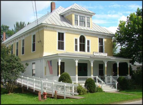
Vassalboro Grange (photo: vassalboro.net)
The mother and father of all United States agricultural organization is the Grange, formally known as the Order of Patrons of Husbandry. The national Grange was organized in Washington, D. C., on Dec. 2, 1867, by a seven-person group headed by Oliver Hudson Kelley (1826 – 1913), a Bostonian who moved to Minnesota in 1849 to become a farmer.
A Grange historian quoted in Ruby Crosby Wiggin’s Albion history wrote that the organization was a response to the “depressed condition” of agriculture after the Civil War. The 1873 financial panic hastened its growth.
In 1864, Kelley, working for the national Bureau of Agriculture, inspected post-war farming conditions in the southern states. He realized the need to help farmers earn their living from their land, found like-minded friends and created the Grange.
Kelley intended the organization as “an agricultural fraternal order,” not unlike Masonry, with rituals, named offices, degrees and an aura of secrecy, Maine Grange historian Stanley R. Howe wrote in a 2010 article reproduced on line.
“Fraternal” was never accurate, however; Howe credited Kelley’s niece, feminist Caroline A. Hall, with gaining women near-equality in the Grange. They had voting rights from the beginning and four of the 16 elected offices in each Grange are exclusively for women.
(Online information says in 1893 the Minnesota Grange elected a woman named Sarah Baird as the first female state Grange President [Master] in the United States. Minnesota’s current state Grange president is a woman, and so is the president of the national Grange, for the first time: Betsy Huber, of Pennsylvania, a Granger since she joined a Junior Grange at age five, has been national president since 2015.)
The name Grange comes from Great Britain, where the part of an estate used for agriculture was called the grange, Howe explained.
As the organization developed and spread, four main purposes emerged.
Economic improvement remained central. Means included cooperative stores, where the organization bought in bulk and sold to members at cost; discounts on things like life and health insurance; and spreading information about improved agricultural techniques, new machinery or seeds and other benefits to farmers.
Education, agricultural and general, was important. Granges published reports, newspapers and bulletins; many Grange halls had libraries; most Granges sponsored educational presentations on topics important to local farmers and the community; many hosted classes and workshops.
Having an organization that operated locally, state-wide and nationally gave Grangers political clout. One of the first national efforts was to pressure Congress to lower railroads’ shipping rates so that farm products could be sent to market more cheaply. Grangers also wanted grain elevators’ charges controlled.
The Grange lobbied for the postal service’s Rural Free Delivery system, so that isolated farmers would not have to choose between driving miles to the post office or paying a commercial carrier to pick up their mail. Grangers supported a variety of national cooperative farmers’ institutions; one source says they were instrumental in making the head of the United States Department of Agriculture a member of the President’s Cabinet in 1889.
Grange members lobbied for the Prohibition movement (implemented by the 18th Amendment to the United States Constitution, in effect Jan. 16, 1919, and repealed by the 21st Amendment, in effect Dec. 5, 1933). They helped implement progressive political ideas, like direct election of Senators (the 17th Amendment, in effect April 8, 1913) and voting rights for women (the 19th Amendment, in effect Aug. 18, 1920). Current national President Huber advocates expanding access to broadband service, especially in rural areas.
Complementing these economic, educational and political goals, at the local level the Grange became the social center for rural towns across the country, providing a community meeting hall and sponsoring suppers, dances and local and imported entertainments. One historian called this function especially important to rural women, who were more isolated than the men.
The Maine State Grange was organized in Lewiston on April 21, 1874, a year after the first Grange in the state was established in Hampden. Grange and state websites say there were 64 Maine Granges with about 2,000 members by the end of 1874; within two years, 228 Granges and 12,000 members; in 1907, 419 Granges and more than 55,000 members; and in 1918, 450 Granges and 60,000 members. Membership peaked at around 62,000 in the 1950s and has declined in recent years.
In 1918, according to that year’s Maine Register, W. J. Thompson, of South China, was Master of the state Grange. His wife held the position of Flora (one of three ritual stations, with Ceres and Pomona, Howe explained) and D. E. Foster, of Augusta, was Steward.
(Wikipedia says Ceres was “the Roman goddess of agriculture”; Flora was “the Roman goddess of flowers” and of spring; and Pomona was “the Roman goddess of fruit and nut trees.”)
Political positions the Maine State Grange took included supporting funding for local schools and the University of Maine and opposing the repeated efforts to move the state capital from Augusta. Augusta’s Maine Farmer newspaper, published from 1823 to at least 1900 (see The Town Line, Nov. 26, 2020), was a Grange publication.
The organization promoted causes that benefited not only farmers, but other segments of society. Howe mentioned sending care packages to soldiers overseas during World War II and building and supporting Grange Cottage to house orphans at Goodwill-Hinckley School, in Fairfield.
Since 1945, the Maine State Grange has been headquartered on State Street, in Augusta.
In the 1880s the state organization added county Granges, called Pomonas. Juvenile Granges started in 1944; Palermo’s Sheepscot Lake Juvenile Grange #106 and Augusta’s Capital Junior Grange #274 were active in the 1950s and 1960s.
A current on-line list from the Maine State Grange says there are 103 active Granges in Maine, counting both local and county Granges. Local ones listed are Benton Grange, Fairfield Center’s Victor Grange and Branch Mills Grange, in Palermo; Vassalboro Grange, in East Vassalboro, should also be on the list, according to its Facebook page.
Albion Grange #181 was one of the earlier local Granges, past and present. Maine State Grange Master Nelson Ham oversaw its organizational meeting on July 6, 1875, historian Ruby Crosby Wiggin wrote. There were 36 charter members: 34 couples, the son of one couple and an unmarried woman.
Wiggin said in 1875, only farmers and their families were eligible to join the Grange. Doctors, storekeepers and all other non-farmers were excluded.
In 1873, Albion residents had organized a local stock company to build a community hall. The hall was finished in 1874, and the first Grange meeting was held there.
Until January 1881 Grangers rented the hall only for meetings. In January 1881, the Stock Company leased it to the Grange at $35 a year, and in 1886 the Grange bought the building.
Beginning in October 1875 Grangers ran a cooperative store, buying a variety of items – coffee, salted fish, cloth, raisins, rock salt, cheese, sugar, chewing tobacco, grass seed – in bulk and selling them to members. Meetings included panel discussions, suppers and other forms of entertainment.
On Oct. 4, 1879, Albion Grange held its first fair, in conjunction with Freedom Grange. Independent Albion Grange fairs were held annually into the early 1950s, Wiggin wrote.
By 1892, Henry Kingsbury wrote in his Kennebec County history, Albion Grange had 150 members. In 1902, the Maine State Grange Proceedings says there were 252 members.
In 1903 Grangers added a dining room to their building, which they still used when Wiggin published her Albion history in 1964. On-line sources suggest the Grange had been re-established in 1957, probably after an interval of inactivity.
In Augusta, records show two Granges. The earlier, Capital Grange #248, was organized April 7, 1883, according to Capt. Charles E. Nash’s chapter on Augusta in Kingsbury’s history. The second Capital Grange Master was Samuel L. Boardman, who wrote the chapter on agriculture in the same book.
On Nov. 12, 1901, according to records of the national Grange, Brother Obadiah Gardner carried an invitation to those attending the national convention to visit Augusta on Nov. 19, traveling by train. The flowery letter was signed by Capital Grange Master G. M. Twitchell and Augusta Board of Trade President C. B. Burleigh.
Attractions included touring the city and the State House; meeting Governor Hill and his wife at “the mansion of the late Hon. J. G. Blaine, which remains as it was when he did his great work”; and visiting “the national home at Togus,” then caring for 2,600 Civil War veterans.
The Grange records say that Brother W. K. Thompson, of South Carolina, moved to accept the invitation. Discussion was postponed from the morning to the afternoon session, when Brother Thompson’s motion was “considered at considerable length and unanimously adopted.”
(Obadiah Gardner [1852-1938], a Michigan native who moved to Maine in 1864, graduated from Coburn Classical Institute, in Waterville, and farmed in the Rockland area, was Master of the Maine Grange from 1897 to 1907. He ran unsuccessfully for governor in 1908; was appointed to the United States Senate in September 1911, after William P. Frye died in office; and lost his re-election bid in 1912, leaving the Senate March 3, 1913. He was then appointed to the International Joint Commission to deal with boundary-water issues between the United States and Canada, on which he served until 1923.)
In 1902, M. F. Norcross, the Deputy of West Kennebec County, reported on his Nov. 21 visit to Capital Grange, which then had 60 members. He found there were “[n]ew rituals and badges,” and the members were much interested in “working the third and fourth degrees” under a capable Master. “Bound to succeed,” he summarized.
Later references to Capital Grange are hard to find. The on-line index to the University of Maine’s Raymond L. Fogler special collections library says the library has 110 years of Capital Grange treasurers’ records, from 1883 to 1993.
Capital Junior Grange seems to have been created in or before 1955 and to have lasted until at least 1961.
North Augusta Grange #348 was founded in or before 1899 and existed until at least 1973. In the 1902 Proceedings of the Maine State Grange, Norcross, reporting as Deputy for Kennebec County, said North Augusta Grange had 126 members and a Degree Team and appeared to be doing well.
Nineteen pages later in the same book, Norcross, listing himself as Deputy for West Kennebec County, reported on his Nov. 4 visit to the North Augusta Grange. The Master told him meetings had been suspended temporarily “on account of a drama.” Norcross gave no details, but commented, “It is hoped that the work that the Grange is designed to do is not made a secondary matter.”
19 Granges in the central Kennebec River valley, in the order in which they were founded (as nearly as this writer can determine)
Victor Grange #49, Fairfield Center; established 1874, still active.
Oak Grove Grange #167, North Vassalboro; May 11, 1875.
Albion Grange #181; July 6, 1875.
Albion Grange #181, Oct. 28, 1957; suspended Aug. 26, 1998, for failure to file state corporate reports (according to an on-line source).
Sidney Grange #194; November 24, 1875.
Cushnoc Grange #204, Riverside (Vassalboro); January 13, 1876.
Capital Grange #248, Augusta; Apr. 7, 1883.
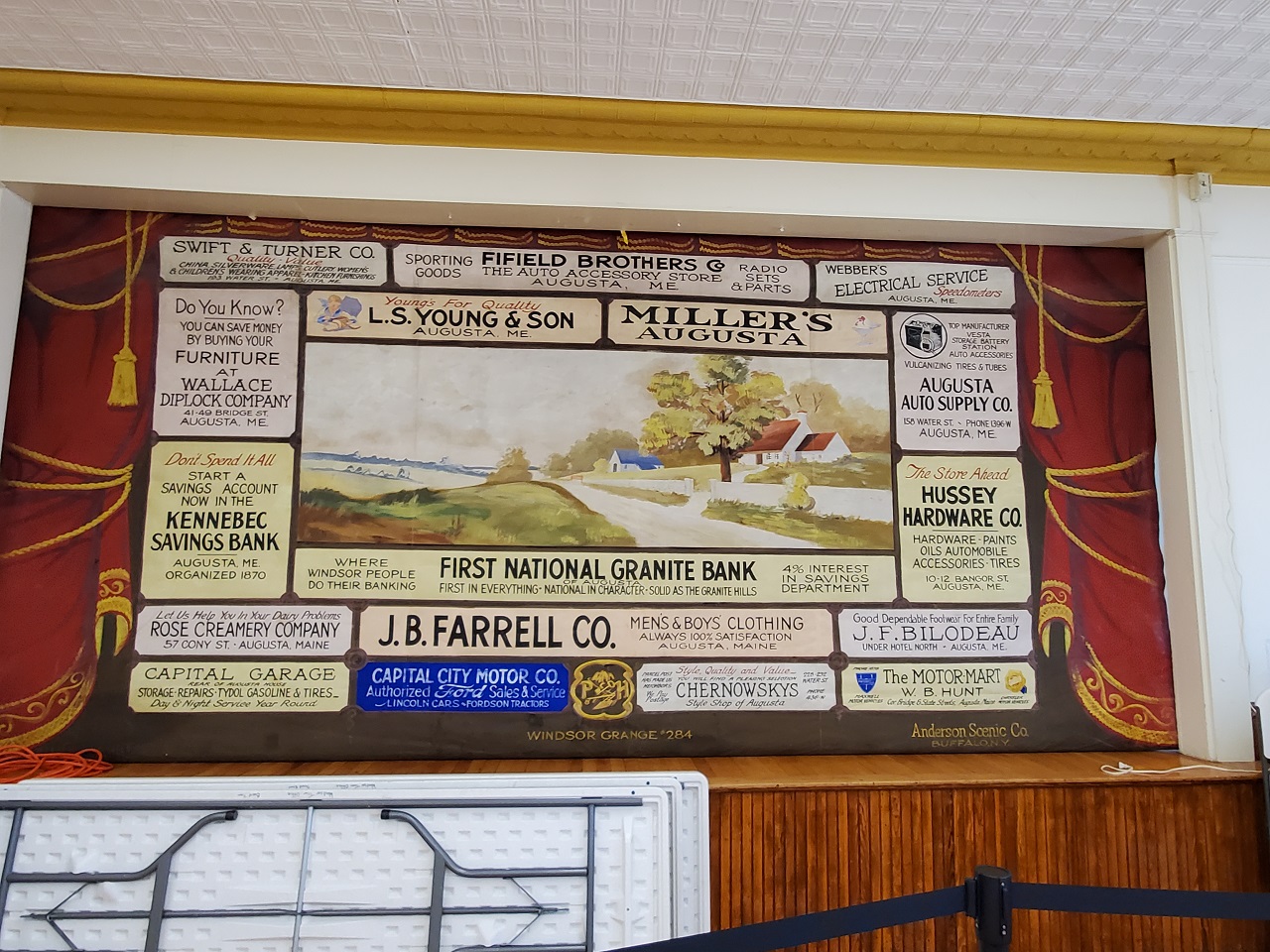
Windsor Grange #284; June 2, 1886.
China Grange #295, South China; December 29, 1887.
Clinton Grange #287; March 1888 (according to Kingsbury; this date is out of sequence).
Clinton Grange #287, July 15, 1949; dissolved Sept. 6, 2006, for failure to file state corporate reports (according to an on-line source).
Winslow Grange #320; in existence by 1894.
East Vassalboro Grange #322, 1895; still active.
Silver Lake Grange #327, China Village; 1895 or 1896.
Branch Mills Grange #336, Jan. 1, 1897 (organized in China, most of its life in Palermo); still active.
North Augusta Grange #348, in existence by 1899.
Sheepscot Lake Grange #445, in existence by 1905.
Benton Grange #458, 1906; still active.
China Lake Grange #578, also called China Grange; fall 1974-1976?, China Village.
19 Granges in the central Kennebec River valley, alphabetical by municipality
Albion (two) Albion Grange #181, 1875; Albion Grange #181, 1957.
Augusta (two) Capital Grange #248; North Augusta Grange #348.
Benton Grange #458.
China (three) China Grange #295; Silver Lake Grange #327; China (Lake) Grange #578.
Clinton (two) Clinton Grange #287, 1888; Clinton Grange #287, 1949.
Fairfield Center Victor Grange #49.
Palermo (two) Branch Mills Grange #336; Sheepscot Lake Grange #445.
Sidney Grange #194.
Vassalboro (three) Oak Grove Grange #167; Cushnoc Grange #204; East Vassalboro Grange #322.
Waterville had none, apparently.
Windsor Grange #284.
Winslow Grange #320.
Main sources
Kingsbury, Henry D., ed., Illustrated History of Kennebec County Maine 1625-1892 (1892).
Wiggin, Ruby Crosby, Albion on the Narrow Gauge (1964).
Websites, miscellaneous.


 by The Town Line staff

 Memorial Day Services