Up and down the Kennebec Valley: Palermo

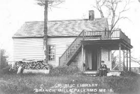
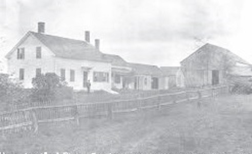
The Branch Mills Library in the 19th century. (Internet photo)

by Mary Grow

Palermo is the only town in this series that is not in Kennebec County. The boundary line between China on the west and Palermo on the east is also the line between Kennebec and Waldo counties. It runs through Branch Mills, formerly Palermo’s main commercial center.

It is not Palermo residents’ fault that they don’t live in Kennebec County. In 1760, all of Maine was organized as Lincoln County; divisions since then have created the present 16 counties. In 1789, part of Lincoln County, not including current Palermo, became Hancock County. On Feb. 7, 1827, Waldo County was created from parts of Hancock and Lincoln counties and included Palermo.

On Feb. 23, 1827, historian Millard Howard says in An Introduction to the Early History of Palermo, Maine, (second edition, December 2015), Palermo voters unanimously asked the legislature to add them to Kennebec County. Their request was not granted.

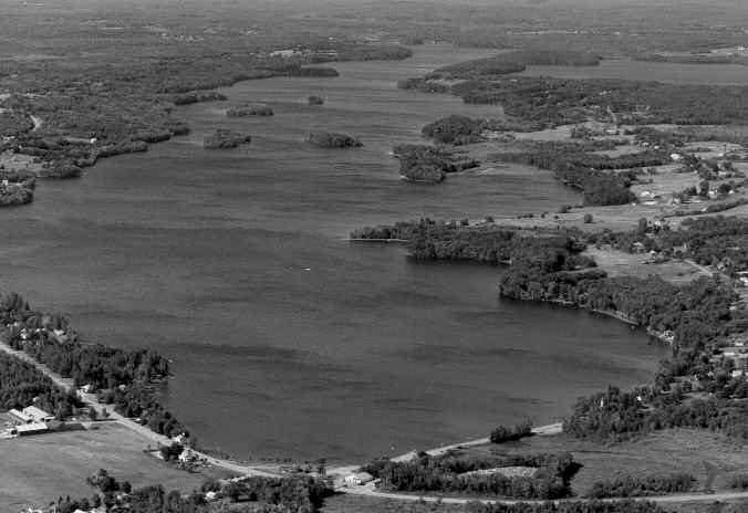
Nor is Palermo part of the Kennebec River watershed. Instead, the town is doubly in the Sheeepscot River basin. Branch Pond and Branch Mills, on the western edge of the town, are on the West Branch of the Sheepscot, and Sheepscot Pond, which fills about a third of the southern half of Palermo, is on the main stem. The two rivers join well south of town, between Coopers Mills and North Whitefield.

A multitude of small ponds are scattered through northern Palermo; not all have names on the contemporary Google map. Named ponds include, in a northern tier and moving from east to west, Prescott, Nutter and Chisholm.

The next tier south, approximately east of Branch Pond, includes, from east to west, Bowler, Foster and Belden. South of them are Dowe Pond on the east, not far from Branch Mills; Saban Pond and to its south Bear Pond, about mid-way between the eastern and western boundaries; and Jump Pond, south of Foster Pond.

Beech Pond, near Greeley’s Corner (or Greely Corner, or Center Palermo) between Parmenter and Cain Hill roads, is the final named pond north of Route 3. South of the highway, Sheepscot Pond has a tiny nameless blue spot on the map to its northwest; Turner Pond, shared with Somerville, on its southwest; and on the southeast another blue spot identified as Deadwater Slough.

According to Howard, Stephen Belden, his wife Abigail and their son Aaron were Palermo’s first settlers, in 1769. Their second son, Stephen, Jr., was born in 1770, the first settlers’ child born in Palermo.

The Beldens chose not to homestead beside Sheepscot Great Pond, as Sheepscot Pond was then called. Howard suggests they chose a more secluded location because they were squatters with no legal title to the land and did not want visits from agents of the Kennebec Proprietors, owners of a large tract 15 miles on either side of the Kennebec River.

Howard locates the first Belden homestead only by late 20th century owners Robert and Susie Potter. Later, he said, the Beldens moved to the shore of what was then Belden, and later became Bowler, Pond.

Other people who arrived in the 1700s, according to Howard (who did a great deal of research in early documents) were Hollis Hutchins (1775), who, Howard says, settled “in the lower Turner Ridge area”; Jacob Greeley, Jr, (1777) and John Foye (1778), near Beech Pond; and Jonathan Bartlett (1788), who built the first sawmill on the Sheepscot south of Sheepscot Great Pond.

Other early names Howard mentions include Albee, Boynton, Bradstreet, Cressey, Lewis, Turner and Worthing. Ava Harriet Chadbourne’s Maine Place Names and the Peopling of Its Towns (1955) adds Bowler, Clay, Longfellow and Waters in the 1770s and 1780s. Many settlers had large families who intermarried through the generations. For example, Howard says Hollis Hutchins’ five sisters married into the Albee, Boynton, Cressey, Foye and Turner families.

The area was first called Sheepscot Great Pond Settlement. After an 1801 survey of 27,100 acres by William Davis of nearby Davistown (now Montville), it was organized as Sheepscot Great Pond Plantation. Howard says the first clerk of the plantation was a well-liked 24-year-old doctor from Vermont named Enoch P. Huntoon.

Immediately after the plantation was created, 55 residents asked the Massachusetts General Court to make it a town and to name it Lisbon. The requested name, Chadbourne and Howard explain, was part of a trend to name Maine towns after important foreign places – hence the famous Maine road sign that lists seven foreign countries honored in Maine plus Naples and Paris (but omits Belgrade, Lisbon, Palermo, Madrid, Rome, Sorrento and Verona Island).

The Lisbon on the sign is the Androscoggin County Lisbon between Lewiston and Brunswick, not the one requested in Waldo County. Lisbon was settled in 1628, its website says, and incorporated as Thompsonborough in June 1799. In December 1801 residents asked the Massachusetts legislators to
change the name to something less cumbersome, suggesting Lisbon. On Feb. 20, 1802 (after Sheepscot Great Pond’s petition was filed but before the legislature acted) Thompsonborough became Lisbon.

Sheepscot voters looked for another capital. They also realized that the P. in Dr. Huntoon’s name stood for Palermo. On June 23, 1804, the Massachusetts General Court approved the incorporation of the town of Palermo. Howard wonders if local residents realized Palermo in Sicily had been an important medieval center and, in his opinion, was a better choice than Lisbon.

Early transportation in Palermo was by the Sheepscot River and by trails. One of the functions of a town government was to lay out, build and maintain roads; Howard says Palermo officials were especially active from 1805 until about 1820. The first road linking the southern settlements with northern Palermo followed a route approximated by the present Turner Ridge Road (which joins Route 3 from the south at Greeley’s Corner, east of Beech Pond); Parmenter Road (which goes north off Route 3 west of Beech Pond); and Marden Hill Road (Parmenter Road’s name north of the four-way junction with Nelson Road and Belden Road). Marden Hill Road continues northeast to connect with North Palermo Road.

The southern end of town gradually lost importance. By the 1820s, Howard mentions five centers along or north of present Route 3: Branch Mills; Greeley’s Corner; Carr’s Corner on the North Palermo Road west of Prescott Pond; Ford’s Corner, where the North Palermo and Chisholm Pond roads meet; and East Palermo, the junction of Banton Road and Route 3.

A “center” would have at least one public building and/or business and a cluster of houses. The public building might be a post office; at various times, Branch Mills, Center Palermo, North Palermo and East Palermo had one. In the 1860s, Howard says, Greeley’s and Carr’s corners each had at least one store, at least one church and a school.

Howard found that Palermo reached its greatest growth in terms of population around 1850. He cites a series of census figures: 1790, 164 people counted; 1800, an almost threefold increase to 444; 1820, 1,056, the first count over 1,000; 1840, 1,594; 1850, the highest recorded, 1,659. A gradual decline began with a loss of almost 300 by 1860. By 1890, the population was again below 1,000, at 887. Howard’s list stops at 1950, when the population was recorded as 511. A steady increase began in 1970, and the 2010 census recorded 1,535 inhabitants, almost back to the pre-Civil War high.

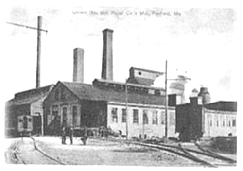
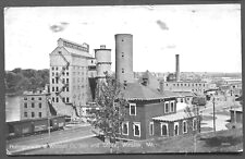
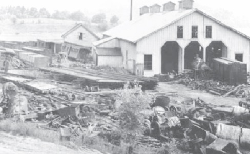
The old Dinsmore Mill, in Branch Mills. (The Town Line file photo)

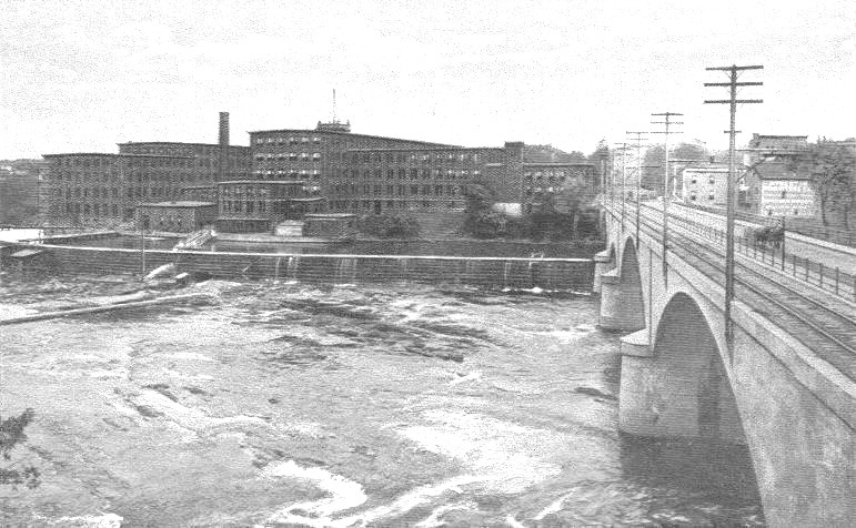
The 1886 Gazetteer of the State of Maine says Branch Mills was then the largest village, with eight mills. Center Palermo had a “board and shingle-mill” and a stone quarry; East Palermo had two lumber mills; and North Palermo had a factory that made drag-rakes.

One of the mills in Branch Mills was the Dinsmore Grain Company Mill, on the China side of town. The mill building and its associated dam stretched across the Sheepscot River, with access to the building from the east shore.

The first mill on the site was built in 1817 by Joseph Hacker, according to a Wikipedia article. Hacker’s son-in-law, Jose Greely, succeeded him, and in 1879 Greely took his son-in-law, Thomas Dinsmore, as a partner. Thomas Dinsmore’s son James Roscoe Bowler Dinsmore succeeded him.

The 1908 fire that destroyed most of Branch Mills destroyed the mill as well. James R. B. Dinsmore rebuilt it in 1914 as a two-and-a-half-story wooden building, shingled, with a three-story tower on the south side. Initially it was only a grist mill, in 1935 James Kenneth Dinsmore (James R. B. Dinsmore’s son) added a sawmill operation, which continued until 1960.

On Nov. 3, 1979, the Dinsmore mill was added to the National Register of Historic Places. Subsequent owners proposed reusing it, but none succeeded. Both the building and the dam deteriorated, to the point where waterfront property owners on upstream Branch Pond complained that the dam no longer kept water levels high enough for recreation. The Maine Department of Environmental Protection also objected that its water level regime for Branch Pond was violated.

By 2016, the mill owners claimed the building was too dangerous to repair. In 2017, the Atlantic Salmon Federation acquired the property, tore down the historic building and negotiated with state regulators to add a fishway for salmon and other anadromous fish to the dam.

Main sources

Howard, Millard An Introduction to the Early History of Palermo, Maine (second edition, December 2015)
Web sites, miscellaneous

Note: Milton E. Dowe’s highly recommended History Town of Palermo Incorporated 1884 was published in 1954. Unfortunately, with libraries closed it was not available to this writer in time to be studied.

Up and down the Kennebec Valley: Albion

Pierce Family Homestead, in Albion.

by Mary Grow

There is debate over names of the first settlers in what is now Albion, partly because records are incomplete, partly because current Albion once included parts of several other towns. For example, Nathaniel Wiggin’s and several other families’ holdings at the north end of China Lake’s east basin were in Albion before the Albion-China boundary was moved north and their land became part of China.

Ruby Crosby Wiggin, in her well-researched and well-illustrated Albion on the Narrow Gauge, lists Burrills (Belial Burrill, by 1790), Crosbys, Davises (Samuel Davis, listed in the 1790 census), Fowlers, Haywoods (Nathan Haywood, by 1793) and Lovejoys. Kingsbury’s Illustrated History of Kennebec County 1792-1892 adds Libbeys (elsewhere Libbys), Prays, Shoreys and Rev. Daniel Lovejoy.

The last, Wiggin says, is probably an error. She found records in which Daniel Lovejoy’s sons said Daniel’s father, Francis Lovejoy, brought the family to settle on Fifteen-Mile-Pond (later Lovejoy Pond) when Daniel was about 14, making Francis an early settler.

Albion resembled other area municipalities in changing its boundaries and its name repeatedly. Wiggin says when the area was incorporated in 1802 as a plantation called Freetown, it was nearly square. A 20th-century map shows parallel boundaries on the east and west. On the south, a rectangle with a slanted east end indicates the 1815 transfer of the China Village area from Albion to China. The north boundary is irregular.

Wiggin says in 1803 Freetown voters asked the Massachusetts General Court to upgrade the plantation to a town. On March 9, 1804, the town of Fairfax was incorporated. In March 1821 (by then by the Maine legislature’s action) Fairfax became Lygonia (sometimes spelled Lagonia).

In January 1823, town meeting voters chose a five-man committee to ask the legislature to change Lygonia to Richmond. The petition apparently failed, for a January 1824 meeting created a seven-man committee (Daniel Lovejoy and John Winslow served on both committees) to request a change back to Fairfax. On Feb. 25, 1824, the name Albion was approved, Kingsbury says; and Wiggin says voters accepted it at an April 5, 1824, meeting.

Ava Harriet Chadbourne’s adds the following information, without specifying cause and effect. Fairfax was an 18th-century English general (the web suggests Sir Thomas Fairfax [Jan. 17, 1612 – Nov. 12, 1671], commander in chief of Oliver Cromwell’s Parliamentary army).

Lygonia was the name of a former land grant in York County, Maine (whence many Albion settlers came), to Sir Ferdinando Gorges. The web adds that Gorges named the 1,600 square mile piece in honor of his mother, Cicely Lygon Gorges.

Albion was an early Greek and then Roman name for the island that became England.

In the early 19th century, Albion settlement expanded from the area between China Lake and Lovejoy Pond, sometimes called South Albion (Wiggin points out there seem to have been three areas called South Albion, and Kingsbury mentions two, with Puddle Dock the second) as stream and road junctions provided places for mills and businesses.

Fifteen-Mile Stream and tributaries meander from southeast to northwest. Kingsbury lists numerous mills; some of the earliest were William Chalmers’ gristmill and carding mill on Fifteen-Mile Stream before 1800; Josiah Broad’s sawmill and gristmill on the same stream’s east branch before 1810; Robert Crosby’s sawmill around 1812 in what Kingsbury and Wiggin call the Crosby neighborhood, with, Wiggin says, two dams across a small stream; and Levi Maynard’s sawmill, fulling mill, carding mill and gristmill, built about 1817 near a bridge across Fifteen-Mile Stream east of Albion Corner.

Albion historian Phillip Dow adds that the stream was named because part of it was 15 miles from Fort West­ern, in Aug­usta. It originates in a bog in Paler­mo, he says; runs northwest through a bog in northern Albion; continues north and west and is supplemented by another stream from Fowler Bog, in Unity; and eventually joins the Sebasticook River that flows into the Kennebec River.

Kingsbury says Nathan Haywood and Joel Wellington owned the only two taverns in Albion before the stagecoach route from Augusta to Bangor started running through town in 1820. (Joel was also Al­bion’s first postmaster when the post office was established in March 1825.) Joel’s brother, John Well­ington, opened another tavern in 1820 at Albion Corner, which Kings­bury says he ran until it burned in 1860.

A fire at Besse High School, in Albion, in 1958.

There have been two Albion Cor­ners, in addition to the three South Al­bions. John Wellington’s tavern was at the eastern one, where the Hussey Road runs south off the main road (this Albion Corner is labeled on the map in the 1879 Kennebec County atlas). About the same time Well­ing­ton’s tavern opened, Kings­bury says Ralph Baker opened an inn at the present Corner, where the China and Win­slow roads meet.

Other businesses in the first quarter of the 19th century included at least two blacksmith shops and at least five stores in different parts of town. The latter, Kings­bury comments, were needed to provide three necessities that settlers could neither find in the water or woods nor grow in their fields: molasses, tobacco and rum.

Albion Corner seems to have been Albion’s main commercial center, but Wiggin reports a thriving area at Puddle Dock in the mid-19th century. The 1856 Albion map shows 21 buildings in the area, she says, including George Ryder’s store that housed the post office. In 1856, South Albion is south of Puddle Dock, near the China and Palermo town lines.

The 1879 atlas’s map shows at least a dozen buildings near Puddle Dock still, including a schoolhouse on the east bank of Fifteen-Mile Stream. This map shows the South Albion post office at Puddle Dock.

Wiggin describes the stage route between Puddle Dock and Fairfield around 1894. The Puddle Dock postmaster was M. J. Hamlin, she says. Stage-driver Martin Witham made two trips a day with mail, passengers, freight or all three, pulled by one horse in good weather and two if travel were difficult. From Puddle Dock the stage went through Albion Corner to East Benton and via three more Benton stops to Fairfield.

Some area residents still remember the dance hall at Puddle Dock. Dow says its first incarnation was in the 1940s and 1950s, when it was what he calls “a rough joint.” It closed for several decades and, Dow says, was briefly revived in the 1980s.

Daniel Lovejoy, mentioned above, had seven sons, of whom three became nationally known: Elijah Parish Lovejoy, born in 1802, martyred in Alton, Illinois, in 1837 for his anti-slavery activities; Owen Lovejoy, born in 1811, active abolitionist and member of Congress from Illinois from 1857 until his death in office in 1864; and John Ellingwood Lovejoy, born in 1817 and for three and a half years U. S. Consul to Peru, appointed by President Lincoln.

Kingsbury and Wiggin present the Crosbys as another important Albion family for many generations. The first connection was through Rev. James Crosby, one of the first settlers; Wiggin says he came around 1790. His great-grandson, George Hannibal Crosby (born in 1836) spent his working life in Massachusetts, where he was a mechanical engineer who invented and patented more than 30 improvements on gauges and valves and founded the Crosby Steam Gauge and Valve Company.

In 1886, he returned to Albion, married for the second time (to a cousin, also a Crosby), and bought a 250-acre farm on Winslow Road that had a stream and a pond. He moved the farmhouse across the road and replaced it with the Crosby Mansion, which he designed. Dow locates the Mansion (Wiggin capitalizes it) on the east side of the Lovejoy Pond outlet.

Kingsbury reproduces two pictures of the elaborate building. Wiggin includes plans of two of the five floors; the first had three piazzas, two looking west and one looking east. One piazza, she says, was built around an elm tree, because Crosby disliked removing trees. The third floor contained seven bedrooms; above it were the attic and the cupola.

The Mansion cost $75,000 or more in 1886 dollars. A feature Crosby proudly showed to visitors was a bathroom on the second floor, at the head of the south stairs. Water for flushing was stored in a third-floor tank; pulling a chain brought it down. The wooden bathtub was zinc-lined.

Waterville, Wiscasset and Farmington Railway yard.

Dow, who has researched the history of the narrow-gauge Wiscasset, Waterville and Farmington Railroad (1895 to 1933), says Crosby supported the railroad and encouraged building the line across his land so passengers could see his house. One map of the railroad on the web shows the Crosby Tank (one of many places where train crews could take on water for the engine), and Wiggin refers in her history to Crosby’s Crossing.

After Crosby’s death the family lost the Mansion. It had several tenants and owners before it burned on Dec. 27, 1914. Wiggin says it was empty at the time and no one knows how the fire started. When she was writing 50 years later, a local family was using a piece of tile salvaged from the ruins as a hot dish mat.

Twenty-first-century Albion has a concentrated downtown around the two Albion Corners, with Lovejoy Health Center, Lovejoy Dental Center, a pharmacy, the elementary school, the town office, the library, the fire station, stores and other public and private buildings close together.

From August 1927 until January 2013, H. L. Keay & Son’s general store was one of the downtown anchors. According to a Jan. 13, 2013 Central Maine Morning Sentinel article, Harold Keay, with his wife Lena, ran the store from 1927 until his death in 1982. His son Crosby then took over; he died Nov. 26, 2011, aged 86. By 2013 the store was co-owned by Crosby Keay’s four children, Daryl, Jerry and Kevin Keay and Lisa Fortin.

Starting with a small grocery store, Harold and Lena Keay added space and inventory until by 2013 grandson Kevin Keay said the store was 8,000 square feet and there were another 8,000 square feet of warehouse. In addition to groceries, the store sold hardware, lumber and building supplies and other miscellaneous items small-town people need, and, residents commented to the Sentinel reporter, it was the place to catch up on local news.

Kevin Keay told the Sentinel business had fallen off because of the economy and competition from chain stores like Hannaford and Walmart.

The former Keay’s store has been run for a year by Andy Dow (Phillip Dow’s son). The nearby Albion Corner Store is run by Parris and Cathy Varney, of China.

Main sources

Kingsbury, Henry D., ed. Illustrated History of Kennebec County Maine 1625-1892″ 1892.
Personal interview
Wiggin, Roby Crosby Albion on the Narrow Gauge, 1964.
Web sites, miscellaneous.

The history of the Kennebec Water District

Most information in this section is from the comprehensive history section of the Kennebec Water District’s website, which was last updated in 2006.

The Kennebec Water District (KWD) was incorporated on March 17, 1899, the first such quasi-municipal district in the country and the pattern for generations of future water, sanitary, sewer and school districts. It was the brainchild of a lawyer named Harvey Doane Eaton (Sept. 20, 1862 – Oct. 17, 1953). Such districts allow towns and cities to cooperatively supply services like clean water that none could afford to supply by itself.

A for-profit predecessor, the Maine Water Company, controlled KWD’s water supply, which came from Messalonskee Stream, until stream pollution caused a 1902 typhoid epidemic. KWD officials chose China Lake as the replacement water source in 1903 and promptly started building a pipeline from the lake.

In May 1905 China Lake water came to KWD customers. “Water purity is exceptional,” the website says. When another typhoid epidemic in 1910 cast doubt on China Lake water, KWD hired a Harvard professor who found the real culprit: milk.

Between 1909 and 1912, KWD spent about $57,000 to buy China Lake shoreland, saving the estimated $100,000 to $200,000 cost of building a filtration plant. From 1920, the district planted trees in the watershed as another water quality protection measure.

A state-of-the-art filtration plant, at the time the largest in Maine, came on line in August 1991. It was the result of two factors: China Lake’s deteriorating water quality beginning in the 1970s (making “China Lake syndrome” nationally recognized in water quality circles); and the 1986 federal Safe Drinking Water Act, setting standards untreated China Lake water could not meet.

KWD served customers in Waterville, Fairfield, Winslow and Benton from the beginning and added Oakland (by contract) and Vassalboro. The five member municipalities, but not Oakland, are represented on the district board of trustees.

From KWD’s creation in 1899 until 1920, Albert S. Hall served as superintendent. (He was not the Albert S. Hall for whom Waterville’s Albert S. Hall School is named, nor that Hall’s father; according to educator Hall’s obituary, he was born in 1935 and his father’s name was Clifton L. Hall.) KWD’s second superintendent, Alvin B. Thompson, served even longer, from 1920 until 1948.

Up and down the Kennebec Valley: China Lake

A bathing beach on the Causeway, at the Head of the Lake, across from the China Baptist Church. (photo from the Bicentennial History)

by Mary Grow

China Lake is an important area resource for year-round recreation; drinking water in municipalities served by the Waterville-based Kennebec Water District; and, given the high value of waterfront property, taxes for the Town of China.

The United States Geological Survey (USGS), on an undated (but later than 2006) website, says China Lake has an area of 3,845 acres. The Maine Lake Stewards website puts the area at 3,949 acres. Other sites translate the acres to 6.155 square miles or 1,594 hectares.

The USGS and the Lake Stewards agree on a maximum depth of 85 feet, which the USGS says is in the circular west basin, which is mostly in Vassalboro. The long, narrow east basin has a maximum depth of 50 feet, according to the USGS.

There are five mapped islands in China Lake. Bradley Island in the west basin is owned by the Town of China. In the northern half of the east basin, from north to south, are: Green or Bailey on the west, almost side by side with Moody or Teconnet on the east, both privately owned; the privately-owned island listed on China tax maps as John Jones Island; and tiny Round or Indian, owned by the China Baptist Church. Pastor Ronald Morrell says the church welcomes visits to Indian Island by groups and individuals who are respectful of the environment.

The east basin is surrounded by private homes, year-round and seasonal, many on lots covering a fraction of an acre and with 100 feet or less of water frontage. For comparison, standards in China’s current land use ordinance require a minimum 40,000 square foot lot (one acre is 43,560 square feet), at least 200 feet of shore frontage and space to set buildings at least 100 feet from the high-water line. Lots and buildings that don’t meet contemporary standards may continue as they are, but cannot be enlarged or otherwise changed (with a few exceptions).

The Kennebec Water District owns most of the shoreland around China Lake’s west basin in Vassalboro and western China and keeps it undeveloped to protect water quality.

[See also: The history of the Kennebec Water District]

As noted in the May 28 story about the town of China, the area around the lake was first surveyed and settled in 1775. The China Maine Bicentennial History including 1984 revisions (1984) says numerous varieties of fish supplied food for early settlers and still support a year-round recreational fishery. Before electric refrigerators became common in the early 1900s, local residents cut ice from the lake for personal iceboxes.

Like rivers, lakes are transportation avenues summer and winter. The Bicentennial History mentions a ferry connecting the end of Neck Road with South China in the 1850s. From the 1880s to the 1920s, commercial boats offered lake tours. Piers were built outside China Village and in South China and East Vassalboro. The long China Village pier, known as the clubhouse pier, had a shelter with benches at the end.

Boats’ stopping places included a dance pavilion near the shore in South China and Bradley’s Island. The Bicentennial History says in February 1879 the Maine legislature gave Albert M. Bradley, owner of the Revere House, in East Vassalboro, a 10-year exclusive right to operate passenger steamboats on the lake. He and his son, William Bradley, owned the steamboat Una and by the 1890s had built an amusement park with outdoor games and a 100-seat dining room on Bradley’s Island.

The last of China Lake’s big commercial boats, the Bicentennial History says, was Everett Farnsworth’s 35-foot Frieda. For about 10 summers, beginning in 1909, the Frieda made twice-daily trips starting in China Village and visiting South China and East Vassalboro. The schedule was regular enough that lakeside residents could hail Farnsworth as he went by and get a ride.

In the winter, China Lake was a highway for sleighs and later automobiles, as it is now for snowmobiles. The Bicentennial History includes an anecdote attributed to a native: two early vehicles, Model T Fords or contemporaries, collided in mid-lake on a clear winter day with no other traffic to distract their drivers.

Summer residents began arriving in the 1880s and 1890s. Early clusters of summer homes were around South China and off Neck Road, the Bicentennial History says; most summer places along the east shore were built in the 1920s and 1930s.

The Bicentennial History says the first children’s summer camp on China Lake was Camp Teconnet for Girls, founded in 1911 on Moody or Teconnet Island by Massachusetts residents who also ran a boys’ camp in Unity. Camp Teconnet operated until 1925. Campers and staff patronized the general store in China Village, and every summer they presented an evening’s entertainment in the village to benefit a local cause.

The co-ed Friends Camp opened in 1953 and is still in operation under the auspices of the New England Yearly Meeting of Friends. It started in the historic Pond Meeting House, built in 1807 and used for services until 1915. New buildings were added on the Lakeview Drive property from the 1950s on, plus a bathhouse on the Friends’ lakeshore lot where campers and staff take part in water activities.

Frederick Hussey founded Camp Abenakis (1929-1939) for boys on the Pond Road (Lakeview Drive) about three miles south of China Village. The Bicentennial History describes camp activities, based on an interview with Hussey.

China’s second religious camp is on Neck Road across the lake from the Friends Camp, using the grounds and buildings of the former China Baptist Conference Center. According to the history on the China Lake Camp website, the United Baptist Convention of Maine bought a former farm in 1961 and in 1962 opened the China Area Baptist Camp. Buildings were added over the years, but the property never became the year-round destination conference center its founders envisioned. Since 2008 it has been a Christian summer camp hosting different age levels and interest groups at different times.

Farther south on Neck Road, another boys’ camp, Bel-bern, was started in the 1930s by Saul Greenfield, from New York, who built most of the buildings and furniture. After Greenfield’s death about 1950, the camp closed. In 1956 Warren and Doris Huston, from Massachusetts, reopened it as Camp Ney-a-ti and, according to Doris Huston’s May 2005 obituary, ran it for 16 years. Camp Ney-a-ti was still operating in 1984, directed by Robert True and Bradford Harding. By then the property consisted of about 100 acres on both sides of Neck Road.

A yellow and black highway sign in a tree near Camp Ney-a-ti’s driveway read “Cool It.” The Bicentennial History explains that after the road was paved in 1963, traffic went faster; and after the directors built a ballfield on the west side of Neck Road, they worried about campers’ safety crossing the road. Conventional pedestrian warning signs were ineffective, but the Bicentennial History quotes Harding as saying the new sign didn’t merely slow motorists, it made them “back up to make sure they read what they thought they read.”

The Killdeer Lodge at it appeared in 2017, minus the roof over the porch which collapsed several years ago. Left, the lodge as it lays following its razing in October 2018. (Photo by Bob Bennett)

The Bicentennial History lists four former tourist businesses on the east shore of China Lake’s east basin. From north to south, they were: Willow Beach Camps, started in 1936, where the China Food Pantry is now located; Candlewood Camps, also started in 1936 as Cole’s and later Lakeview before it became Candlewood, probably in the 1950s; Killdeer Lodge, part of a recreational and development project started in 1929 on Lakeview Drive and Killdeer Point; and Cony Webber and George Starkey’s four lakeshore rental cabins opened in 1937, about opposite the present MAJEK seafood restaurant, on Lakeview Drive.

China Lake has no public swimming beach. In an effort to implement part of the town’s comprehensive plan, a Lake Access Committee developed a proposal to buy the former Candlewood Camps property. At the polls on Nov. 5, 2013, voters rejected spending $575,000 for the property by a vote of 314 in favor to 1,004 opposed.

The China Baptist Church at the head of the lake has a small waterfront park, which Pastor Morrell says welcomes courteous guests. The China Four Seasons Club owns a beach for its members part-way down the east shore.

There are two public boat launches, one at the head of the lake east of the causeway bridge and one in East Vassalboro south of the Civil War memorial. A former boat launch in South China is no longer maintained.

Main sources

China, Town of Miscellaneous town records
Grow, Mary M. “China Maine Bicentennial History including 1984 revisions” 1984
Web sites, miscellaneous.

Up and down the Kennebec Valley: China

China Village, circa 1914. (Archive photos)

by Mary Grow

The Town of China lies north of Windsor and west of Vassalboro. Much of the town is in the watershed of China Lake, a major influence in the town’s history. Two of the town’s four villages, China Village and South China, lie at opposite ends of the lake’s east basin. The other two, Branch Mills and Weeks Mills, are on the West Branch of the Sheepscot River in eastern China, upstream of Windsor.

China Lake consists of two basins connected by a short strait called The Narrows. The long, narrow east basin runs from the northern end of town about two-thirds of the way to the Windsor line. The irregular circle that is the west basin extends westward into Vassalboro.

The Kennebec Proprietors, who have been mentioned earlier in this series, owned a vast tract on both sides of the Kennebec River. In 1773, they sent John “Black” Jones and Abraham Burrill (or Burrell) to begin surveying the area that became China.

Like earlier surveys along the Kennebec, the Jones-Burrill plan shows rectangular lots starting from the water on both sides of China Lake (then called Twelve Mile Pond, because it was 12 miles from Fort Western in Augusta). In the south end of town, similar lots ran east from the shore of Three Mile Pond. Rangeways separated each tier of lots as the surveyors moved inland.

According to the China Bicentennial History (1975; revised edition 1984), Jones and Burrill started work in the fall of 1773 and finished in the spring of 1774. Jones spent the winter in Gardiner, where he knew the Clark family.

In the summer of 1774, two generations of Clarks and several other families settled around the southern part of China Lake. The Bicentennial History and Kingsbury’s Illustrated History of Kennebec County Maine 1625-1892 (1892) disagree on which Clark came first.

The Bicentennial History quotes from the diary of Benjamin Dow, who wrote on July 17 that he, one of the Clarks, a Burrill (perhaps Abraham), Job Chadwick and Michael Norton had felled the first tree in what they had named Jones Plantation.

The China Causeway at the Head of the Lake, heading west, circa 1914. (Archive photos)

Much of present-day China was settled, if sparsely, before 1800, according to the Bicentennial History and the sources it lists. Wards and Stanleys chose land west of the north end of the lake, toward northern Vassalboro, on Stanley (once Ward’s) Hill. The Wiggins family was apparently the earliest to choose land at the north end of the lake.

Joseph Evans was said to be the first settler in the backland east of China Lake, leaving his wife and family there while he served in the Revolutionary army. By 1802 Caleb Hanson was in the same area. Evans Pond and the Hanson Road that runs along its eastern shore are named after those families.

Farther east, along the West Branch of the Sheepscot River south of Branch Pond (which is mostly in Palermo), records list nine families who started the village called Branch Mills in 1790 or 1800. One of the Clark brothers was probably the first to settle at the south end of the lake, where South China Village developed. To the southwest, at Chadwick’s Corner (where the Arnold Road forks west off what is now Route 32 South or Windsor Road), Ichabod Chadwick was the earliest resident.

The southwestern part of town, now the Weeks Mills and Deer Hill area, seems not to have been settled until the early 1800s. The Bicentennial History says there were a sawmill and a gristmill in Weeks Mills by the fall of 1807, and lists several men surnamed Gray among Deer Hill residents in and after 1809.

Jones Plantation kept its name from 1774 until February 1796, when the Massachusetts General Court approved incorporating it as the town of Harlem. Ava Harriet Chadbourne says in her Maine Place Names and the Peopling of Its Towns that the name was taken from Harlem in the Netherlands, but she does not offer a reason or supporting evidence.

In 1796 Harlem’s north boundary line ran across China Lake south of the present town line. What is now northern China, including China Village, was part of the Freetown settlement, which became Fairfax in 1804 and is now Albion.

The town of China came into existence on Feb. 5, 1818, by act of the Massachusetts legislature. It consisted of the northern half of present-day China plus parts of Fairfax and Winslow, establishing the north boundary substantially where it is now. The southern half, from approximately the location of the current town office on Route 202 (Lakeview Drive) remained Harlem. Records do not show why the separation occurred.

The story of the naming of the town is well-known locally. Japheth C. Washburn, from China Village, represented the new town in the Massachusetts General Court, with instructions to have it named Bloomville. The representative from Bloomfield (which was separated from Canaan in 1814 and added to Skowhegan in 1862) objected that the similarity in names would confuse mail delivery. Washburn proposed China because it was the name of one of his favorite hymns.

The Bicentennial History says on Dec. 18, 1820, Harlem voters asked to become part of China. China did not want them; but town meeting votes and negotiations with legislators – after March 1820, Maine legislators – were unsuccessful. (A June 18, 1821, vote showed one China voter in favor of accepting Harlem and 81 opposed.) In January 1822 the two towns combined and China acquired most of its present dimensions. Harlem continued to elect town officers to close out town affairs for another six years.

The final significant boundary change was on the southeast, where the line between China and Palermo was redrawn in 1830, adding to China a long narrow triangle of land. The Bicentennial History quotes from the description of the new boundary between the two towns, which was also the line between Kennebec and Waldo counties, with its references to lot numbers, “the house of Joseph Hacker” and a beech tree on the north side of the road from Augusta to Belfast.

Each of China’s four villages was a commercial center for most of the 19th century and the first part of the 20th century. The Bi­cen­tennial History lists a wide variety of businesses. Unusual for such a small town, each village had at least one hotel. Probable reasons are roads and China Lake’s summer visitors.

In China Village at the north end of the lake, the hotel was in the building still standing (now a private residence) on the northeast corner of the intersection of Main Street, Causeway Street and Neck Road. The Bi­centennial History says the building dates from the 1820s and was a hotel until the mid-1940s. From 1827 to 1864, General Alfred Marshall was the innkeeper; the inn was a stagecoach stop. Marshall was born around 1797 in New Hampshire; he was a general in the state militia, a state representative for three years and from 1841 to 1843 representative from Maine’s sixth or seventh (depending on the source) district in the U. S. House of Representatives.

The 1907 and 1913 editions of the Maine Register or State Year-book also list the Starkey House in China, run by G. L. Starkey. In 1913, the Gordon House, operated by E. Gordon, was also listed.

South China is now bypassed by both main roads, Route 3 (Belfast Road) running roughly east-west from Augusta to Belfast and Route 202 (Lakeview Drive) coming south along the east shore of China Lake and intersecting with Route 3 and Route 32 (Windsor Road). In the 19th and first half of the 20th century the village surrounded a four-way intersection; incomplete records suggest it had at least two and perhaps four or five hotels.

The Bicentennial History and websites provide evidence of the South China House, in business by 1855 on Main Street east of the church, once run by Sabin Lewis; the J. R. Crossman Hotel in the southeast corner of the intersection by 1879, and an unnamed hotel in that location rumored to have a secret room where fugitive slaves were hidden in the 1850s; T. M. Jackson’s Jackson House in the early 1890s and the Whitehouse from at least 1907 to 1917, neither with a location provided; and a nameless 20th-century hotel on Weeks Mills Road east of Chadwick’s Corner.

Weeks Mills had one long-running hotel and apparently a second early in the 20th century. The Bicentennial History points out that the 1879 map shows the village at the intersection of west-to-east roads connecting Augusta to Belfast and south-to-north roads connecting Windsor and points south to China Village and points north.

Kingsbury writes the large hotel on the south side of Weeks Mills’ Main Street was started as a tavern around 1875, converted to a hotel by Alden McLaughlin, and in November 1887 sold to Abram McLaughlin, who still owned it in 1892. The Maine Register calls it the Weeks Mills House in 1882, the Union Park House in 1888 and 1890. The 1907 Register again lists the Weeks Mills House, run by Charles Chisam; the 1913 edition lists Frank Gardiner’s Lonsdale House and adds Joseph Segee’s Segee House, which reappears in the 1914 and 1915 editions.

In Branch Mills, the Bicentennial History refers in a footnote to the Shuman House, described as a wooden building that could accommodate 25 guests. The 1908 Maine Register lists Mrs. Nellie E. Shuman as the owner. It was one of many buildings burned in a fire that destroyed most of the village on June 26, 1908.

Main sources

Grow, Mary M. China Maine Bicentennial History including 1984 revisions 1984
Kingsbury, Henry D., ed. Illustrated History of Kennebec County Maine 1625-1892 1892

Web sites, miscellaneous

A history of Hussey’s General Store

by Mary Grow

Hussey’s General Store, at 510 Ridge Road (Route 32) just south of the Route 105 intersection, has a website and its own Wikipedia entry, both quoting the store’s slogan, “If we ain’t got it, you don’t need it.” The business has operated for 97 years and is now owned and managed by the third and fourth generations of the Hussey family.

Harland B. Hussey opened the original store in 1923 in a former stable in the northwest angle of the Windsor Corners intersection, Linwood H. Lowden says in good Land & fine Contrey but Poor roads a history of Windsor, Maine (1993). Harland Hussey’s son, Elwin Hussey, recalls that the stable belonged to the Dutton family, who had for many years owned what Lowden calls the Haskell lot, where Hussey’s now stands. Lowden, who did his typical comprehensive research in deeds and other documents on the Haskell lot, writes that Harry Pinkham was running the Dutton store on the Haskell lot when it burned in 1923.

Harland Hussey, his son says, was a cousin of Pinkham’s wife and was running a car dealership half a mile south. He says Harland Hussey sold Stars and Durants (both manufactured in Lansing, Michigan by Durant Motors, Inc., from 1921 to 1931).

When Harland Hussey learned that Pinkham did not plan to rebuild, he bought the whole property, Elwin Hussey says, and opened his store. The stable-become-store building, which is now used as a warehouse, was expanded at least twice, Lowden writes, for the second time in 1947 when Elwin Hussey joined his father in the business.

Elwin and Shirley Hussey had two daughters and one son, whom they named Benjamin Jay. Jay Hussey’s daughter, Kristen (Hussey) Ballantyne, says her grandfather was born in 1923, the same year the store opened. He started working there in his ‘20s, as manager of the electronics and appliances department, and later took over the business.

In 1953 the family built the present store on the southwest corner of the intersection. Ballantyne says her great-grandmother, Harland Hussey’s wife Mildred, took advantage of the expanded space to start the store’s bridal business in 1953 and 1954, and in April 1954 organized a celebration of the new building and the new department.

Jay Hussey and Kristen Ballantyne now co-own the business. Ballantyne says she has worked in the store since childhood; after college, a short career in social work and marriage, she returned to Hussey’s in 2009 and describes herself as co-owner/general manager and overseer of the clothing and bridal departments. Her half-sister, Lindsay French Hannon, has worked in the bridal department for the past 10 years, she adds.

Lowden writes that the first Haskell store was started in 1837, where the north end of Hussey’s store is now, and by 1841 Ambrose Bryant had a second store on the next lot south, under the middle of present-day Hussey’s. Both disappeared in the early 1850s, and the lot was vacant until in September 1874 the Dutton building was moved from South Windsor.

Lowden quotes part of the description of the move from Roger Reeves’ diary (even though, he writes, it had previously been quoted in the Windsor sesquicentennial history). Reeves, who headed the movers, says the building was put onto skids and rollers, and 56 yokes (pairs) of oxen – “the best team that I ever saw together” – were able to move it; but there should have been another 60 oxen, in Reeves’ opinion.

The move took two full days. By the end of the first day, Reeves wrote, “Men worked hard and ate a barrel of crackers and most of a 46-pound cheese with codfish for dessert.” His comment at the end of the second day was, “There has been one heavy hauling without rum!”

Up and down the Kennebec Valley: Windsor

by Mary Grow

Introduction: so far this series of historical essays has focused on towns along the central part of the Kennebec River between Augusta and FairfieldBenton, and on the river itself. Next we’ll move inland to four towns farther east: Windsor, east of Augusta; China, east of Vassalboro; Albion, east of Winslow and southeast of Benton; and Palermo, east of China and barely touching Windsor on the southwest and Albion on the northwest.

Windsor, China and Albion are in Kennebec County; Palermo is in Waldo County. Windsor, China and Albion are in the watershed of the Sheepscot River. The main river flows southwest from Sheepscot Pond in Palermo; the West Branch originates in northwestern Palermo, flows through Branch Pond and joins the main river between Coopers Mills and North Whitefield.

Albion is in the Sebasticook River watershed; the Sebasticook flows into the Kennebec at Winslow.

* * * *

Unlike the Kennebec River towns, towns like Windsor were not always surveyed and settled from the coast or river inland. In his comprehensively researched good Land & fine Contrey but Poor roads a history of Windsor, Maine (1993), Linwood H. Lowden writes that Windsor was settled initially from Bristol via Whitefield to the south, later from China and Vassalboro to the north and northwest. Moving directly inland from Hallowell (later Augusta) on the Kennebec was discouraged by an intervening area of swampy, boulder-strewn land that would not appeal to aspiring farmers, he suggests.

How much Windsor’s settlement lagged behind its northern and southern neighbors depends on the source of information. Lowden says the first documented Windsor resident was Ebenezer Grover, who came from Ballstown (now Whitefield) and took over meadowland in southern Windsor, northeast of the current junction of Routes 17 and 32. Grover came in 1781, but kept his Ballstown farm until December 1786. Lowden cites deeds showing him in a house on the west bank of the West Branch of the Sheepscot River by 1793.

Another early settler was John Linn, who brought his wife and 10 children from Bristol in 1801 and settled in the Windsor Corner area in the middle of town. Windsor Corner, also called Windsor Corners and Windsor Four Corners, is the intersection of Route 32 (also Ridge Road) and Route 105 in the middle of town. In 1807 Linn wrote a letter about his property deed in which he used the phrase that is the title of Lowden’s book.

Henry D. Kingsbury says, in his 1892 Illustrated History of Kennebec County Maine 1625-1892, that Walter Dockindoff (or Dockendorff, according to Lowden) who came from Bristol around 1790, was the first settler. Dockindoff’s land, Kingsbury says, was “about a mile west of Windsor Corner.”

Kingsbury says Dockindoff planted the first apple orchard in Windsor. Lowden believes Linn also started growing apples very early. When Linn sold his property in 1811 to his son, he reserved the right to continue to tend his trees and to move them later (which Lowden says he apparently did).

Lowden adds that by the 1860s Windsor was known for its apples, and they remained important in the agricultural economy until a hard freeze in the winter of 1933-34 killed many trees.

[See also: A history of Hussey’s General Store]

Kingsbury comments that Windsor is unusual in having all or parts of seven separate ponds within town boundaries, none of them very big. Some modern maps, like the 1984 edition of DeLorme’s Maine Atlas and Gazetteer and Google Maps, show six of them and identify five.

The south end of Three Mile Pond juts into northwestern Windsor. Southward is Mud Pond, between Weeks Mills Road and Route 105, unnamed on Google.

Moody or Moody’s Pond, presumably named after an early settler, is north of Route 17, almost due west of the fairgrounds on Route 32. South of that, on the Whitefield line, Windsor includes the northern tip of Given’s or Givens Pond, formerly Longfellow Pond.

In northeastern Windsor, north of Route 105 and northeast of Greeley Road, are Fox Pond and slightly larger Savade Pond. Kingsbury says Fox was named because people saw foxes in the area and Savade is a corruption of “surveyed.”

Kingsbury’s seventh pond, to which he devotes half a paragraph, is extremely small, with steep sides; is in the center of town about three-fourths of a mile south of Windsor Corner; and was first named after Rev. Moses Donnell, renamed Grant Pond by 1892. Kingsbury says it has two significant features, no outlet and, as far as was known in 1892, no bottom.

Rev. Moses Donnell, born in Wiscasset Aug. 25, 1789, was a Methodist preacher who came to Windsor in the spring of 1818. He kept detailed records from which Lowden took information about his strenuous life and how much – or little – money he earned. Lowden lists various houses Donnell probably owned at different times and says he preached in Windsor in 1822 and from 1832 until his death October 2, 1861. After 1838 he was appointed to different “circuits,” preaching in several towns and traveling thousands of miles.

Lowden gives Donnell Pond another name, Dorr or Dorr’s Pond. It is nameless in the 1984 DeLorme atlas and on current Google maps, but the 1856 and 1879 maps reproduced in Lowden’s history show Donnell Pond on the east side of Route 32 a little south of the present Windsor School. Harland Road leaves Route 32 north of the pond and curves southeast around its northern and eastern shores.

(To this writer’s unscientific eye, Donnell Pond appears to be what geologists call a kettle pond. Kettleholes are created when a retreating glacier leaves behind a block of ice that gets covered with sediment and slowly melts, leaving a hole in the ground. Depending on depth, size and location, such holes can become dry land, bogs or ponds. Kettleholes are fairly common in Maine; Stuart and Hamilton ponds in Belgrade, west of the town office, are examples of kettle ponds.)

Another transplant who followed Dockindoff from Bristol was Thomas Le Ballister (Leballister, according to Lowden; Labalister, according to Geo. J. Varney’s 1886 Gazetteer of the State of Maine), who settled on 300 acres in the southeastern part of town and, Kingsbury said, found squatters already there, including Grover and the Trask brothers, Edward and Joseph.

Josiah Jones surveyed 6,000 acres in southeastern Windsor in 1797 on behalf of Grover and others. They called the area Pinhook, apparently because of a kink in the nearby West Branch of the Sheepscot River. By 1799, Lowden writes, it was generally known as Waterford, later sometimes New Waterford. He suggests the name might have been proposed by Richard Meagher, an early land speculator and agent for the Kennebec Proprietors, who came from Waterford County in Ireland. Lowden also cites a single 1805 reference to New Windsor.

On March 3, 1809, Kingsbury writes, the town was incorporated as Malta. That name was an error, according to Lowden, who quotes a petition to the Massachusetts General Court, signed by 43 residents, asking that New Waterford plantation become an incorporated town named Alpha. Legislative documents approved incorporating Alpha; but the final act incorporating the new town in February 1809 showed the name as Malta. Lowden blames “the slip of a clerk’s pen.”

Residents did not like the name Malta, and in the fall of 1820, town meeting voters approved a petition to the Maine legislature to change Malta to Lexington (Lowden does not say why the name was chosen). Again they did not get their way. On March 10, 1821, the legislature passed a bill renaming the town Gerry, honoring Eldridge Gerry (July 17, 1744 – Nov. 23, 1814), Massachusetts governor and later James Madison’s vice-president and the politician after whom “gerrymander” was named.

Residents promptly appointed a six-man committee to choose another name. On Jan. 9, 1822, the town became Windsor. Lowden cannot say why, or even whether, the committee recommended that name. Ava Harriet Chadbourne, in her Maine Place Names and the Peopling of its Towns (1955) says that Windsor is the name of the British royal family but does not explicitly say that Windsor, Maine, honors them.

The main settled areas in early days were in the southern end of town, where Routes 17 and 32 now intersect, and in the middle where Routes 105 and 32 meet. Lowden says the road connecting them, the current Route 32 (Ridge Road), was “an established way” by 1798. There were smaller areas of settlement in West Windsor and North Windsor.

As more people moved to town, the West Branch of the Sheepscot and several smaller streams provided water power for numerous mills, mostly sawmiils and gristmills, and Kingsbury and Lowden list 19th-century stores, blacksmith shops and other businesses scattered throughout.

Although Windsor is not on the Kennebec (it is about 10 miles from the river), Lowden gives three examples of Windsor people involved in Kennebec River activities.

Before 1810, a large seine net at the mouth of Seven Mile Brook, in Vassalboro, trapped alewives that people from Vassalboro, Malta, Sidney and Belgrade shared. The fish were food for the settlers, especially important to poor families, Lowden writes.

In 1810 the Massachusetts General Court passed a law that, as Lowden presents it, explicitly forbade that seine. Lowden does not give a reason. Vassalboro then established its own net farther up the brook and trapped alewives there. Residents of other towns were allowed to buy them, after a delay and at an inflated price.

Lowden quotes the letter Malta selectmen sent to Massachusetts legislators in 1816 asking them, unsuccessfully, to repeal the law. The three selectmen who signed the letter were William Hilton, Walter Dockindorff and John Linn Jr.

In 1834, when the Kennebec Dam Company proposed the first dam across the Kennebec River, Windsor was one of many towns and cities submitting opinions to the legislature. Windsor’s petition, with 57 signatures, supported the dam, saying it “would be of great benefit and utility,” according to Lowden. (See The Town Line, May 7, for more on this and other dams.)

In the 1870s and 1880s, men from Windsor were among the crews cutting ice on the Kennebec. (See The Town Line, May 14, for more on the ice business.) Lowden quotes from Roger Reeves’ diary about both winter and summer work in 1876. In February, Reeves wrote, two men were hired at $1 per day.

Main sources:

Kingsbury, Henry D., ed. Illustrated History of Kennebec County Maine 1625-1892 1892
Lowden, Linwood H. good Land & fine Contrey but Poor roads a history of Windsor, Maine 1993
Hussey, Elwin, and Ballantyne, Kristen (Hussey), emails

Web sites, miscellaneous

Up and down the Kennebec Valley: Log drives and harvesting “frozen gold”

Horses and sleds were used to move ice blocks.

by Mary Grow

In addition to the mills and factories described in the previous article in this series (see The Town Line, May 7), two other uses for the Kennebec (and other Maine rivers) were transporting wood – long logs and four-foot pulpwood, for building and for pulp mills – and chopping cakes of ice for export all over the world. The log drives were mainly north of the Waterville-Augusta area, with pulpwood feeding Keyes Fibre, in Fairfield. Ice harvesting was mainly south of Augusta. But, as Jennie Everson shows in Tidewater Ice of the Kennebec River, people involved in the two activities overlapped.

Both businesses saw their heyday in the middle of the 19th century; both declined as railroad freight supplanted riverboat freight and the need for the products lessened. However, the Federal Writers Project Maine guide says barges and schooners continued to export both products into the 20th century.

River driving was at its peak between 1860 and 1890, according to David C. Smith’s A History of Lumbering in Maine 1861-1960. On the Kennebec, it started a bit later and was continuing, though near its end, when his book was published in 1972.

Wood was cut in the fall and winter and stacked near or on frozen streams, river and lakes. After the ice went out in the spring, logs and pulpwood were prodded downstream from small streams into larger ones, across lakes and eventually to and down the Kennebec River.

The wood normally reached mills in Waterville and Augusta in August or September. Driving ended for the season when streams began to freeze.

River-drivers herded the logs downstream, sometimes from boats, sometimes standing on the floating wood. They used long poles; peaveys, poles with curved hooks on the end used to grasp and move individual logs; and pickaroons, poles with spikes that could be driven into a log to hold or move it. (Peaveys and pickaroons are advertised for sale on the web today.)

Driving pulp and especially long, heavy logs down an ice-cold, swift-moving river was strenuous and often dangerous work. Logs would run ashore and get caught on rocks. They would pile up in head-high jams that had to be untangled and, when the key log was freed, would tumble tumultuously downstream. They would float uncontrollably seaward in floods. Heavy rain in the spring of 1887 washed almost 10,000,000 feet of timber down the Kennebec into the Atlantic, Smith says.

Smith’s description and random paragraphs in Kingsbury’s history suggest that river-driving was a young man’s job. Kingsbury mentions three Benton men who worked as river drivers. Jackson Fitz Gerald, born in 1815, was a river driver as a young man and later a farmer (Kingsbury gives no dates). William F. Wyman, born in 1824, moved from river-driving to farming in 1855. Alpheus Brown, born in 1837, was a river driver until September 1864, when he joined the army; he was a dam builder from 1866 until 1890 and then a farmer.

Manning the log drives.

The Kennebec Log Driving Company was organized in Gardiner on March 27, 1835, with 63 sawmill owners as its members. Members jointly built dams and booms to hold the logs in check, hired drivers, sharing the costs according to each members’ proportion of the logs. (A boom is a series of chained-together logs, often anchored to cribs – square wooden structures in the river filled with rocks – as well as to the shore, to hold back floating timber.)

Kingsbury credits Ira D. Sturgis (again see The Town Line, May 7), a businessman with interests in Augusta, Vassalboro, Nova Scotia and elsewhere, for persuading fellow lumbermen to build many of the booms along the central Kennebec, including one at Five-Mile Island, in Vassalboro, and another in Hallowell. These improvements, Kingsbury says, made it less expensive to separate logs and send them to the owners’ mills.

According to a September 8, 1976, New York Times article archived on the web, the Kennebec Log Driving Company ran the last log drive on the Kennebec in the summer of that year. Writing from Skowhegan, the Times reporter said about 30,000 cords of four-foot pulpwood were boomed about eight miles upstream of the Scott Paper Company’s mill, in Winslow.

The pulp had started downriver from Moosehead Lake in March and the drive was expected to end in October, the article said. Trucks would take over pulp-hauling.

* * * * * *

Ice harvesting on the Kennebec began in the 1820s and, according to Jennie Everson’s Tidewater Ice on the Kennebec, flourished from the 1850s to the end of the 19th century and ended around 1920. Everson was born in 1890, and her family lived on the river in Dresden in a large house where some of the higher-ranking ice company employees often boarded. Parts of her generously-illustrated book are based on her personal experience.

[See also: Remembering ice houses]

Dean Marriner, author of Kennebec Yesterdays, also saw ice-harvesting first-hand during his first year at Colby College in 1909-1910. He describes watching hundreds of men at work on the river south of Augusta.

Marriner says the business started in the spring of 1824 (Everson says 1826), when the brig Orion took floating Kennebec ice to Baltimore and sold it for $700. The first ice houses went up in Gardiner two years later, Marriner says, and building and improving these storage facilities continued for the rest of the century.

Everson lists three ice-houses in Augusta. An 1882 map she includes shows houses on the west side of the river owned by G. E. Weeks and by Getchell and others, with capacities of 2,000 and 3,000 tons respectively. The Getchell business was not far north of the Hallowell line, Weeks’ a bit south of the dam.

By the time an 1886-87 map was published, they were gone and Cony and White owned one with a capacity of 6,000 tons, still extant in 1892 when Kingsbury’s history was published. However, most ice-harvesting was south of Augusta – an 1891 map from the Ice Trade Journal shows four dozen ice houses from the southern edge of Augusta (Cony and White’s) to Bowdoinham and Woolwich, concentrated in Pittston and Randolph.

Ira Sturgis was involved with the ice business, too. Kingsbury says he owned ice houses downriver, including a large one in Wiscasset, and established southern ones in major cities (Washington, Norfolk, Savannah, Charleston and later Philadelphia and Baltimore) so ice could be stored and sold year-round.

In 1895, Bath native Charles W. Morse (Oct. 21, 1856 – Jan. 12, 1933) finished incorporating the Consolidated Ice Company, in Augusta, controlling most of the Kennebec ice-harvesting business. By 1899, Everson writes, his renamed American Ice Company ran all but one ice company on the river (the exception was on Swan Island, in Richmond). American Ice Company also went into the artificial ice business, she says, speeding the decline of river-ice harvesting; electric refrigerators, coming into use by 1815, finished off the industry.

In the 19th century, the working season began after the ice was thick enough, and by then, Everson writes, tree-harvesting was over, so some of the men who had worked as loggers went to work on the river and in the ice-houses.

Everson includes an undated wage table showing that men cutting and loading the ice earned from 15 cents an hour for the lowest-paid categories of workers to 25 cents an hour for a superintendent. In April 1906, for the first time, the workers struck, demanding a 25-cent-an-hour pay raise. To replace the strikers, woodsmen came downriver, and in May a boatload of Italian workers arrived.

The Italians lived in a boarding house close enough to Everson’s farm so that some of them came to buy milk from her father’s dairy. Neither the first nor a second crew stayed after more Maine people came or returned to the ice-house work and the strike petered out. Everson does not say whether the raise was granted.

Work was year-round, because ice that was cut from the river and stored in ice-houses in winter and spring was loaded onto schooners (usually; Everson mentions early 20th-century experiments with steel whalebacks from the Great Lakes and with barges) and shipped all over the world. The major markets were in cities along the east coast of the United States. Everson adds Cuba, Panama, the coasts of South America, India and New Zealand.

Alice Hammond, in her history of Sidney, mentions that residents cut ice for personal use from the Kennebec River and from Messalonskee Lake (Snow Pond) and three smaller ponds in town.

Main sources:

Everson, Jennie G. Tidewater Ice of the Kennebec River (Maine State Museum, Maine Heritage Series #1, 1970)
Federal Writers Project, Maine: a Guide Down East 1937
Hammond, Alice, History of Sidney Maine 1792-1992 1992
Kingsbury, Henry D., ed. Illustrated History of Kennebec County Maine 1625-1892 1892
Marriner, Ernest Kennebec Yesterdays 1954
Smith, David C. A History of Lumbering in Maine (University of Maine Studies #93, University of Maine Press, 1972)

Web sites, miscellaneous

Remembering ice houses

by Roland D. Hallee

As a young lad growing up in the early 1950s, I can still remember my parents having an ice box* in the kitchen of our home in Waterville. That predated us getting a “new fangled” electric refrigerator later in that decade.

In the box, ice was placed in the top compartment, and a small door was closed. As the ice melted, it drained down a tube that passed through the cold section, and into a large tray that was located in a compartment at the bottom of the “fridge.” Once the tray was full, it was emptied.

I can still remember the ice wagon approaching the house every week, on a still unpaved street in the middle of the city, carrying ice chunks. A man would get out of the buggy, take the order, cut the block of ice to size in the wagon, and lugged it in the house with a set of ice tongs. The ice came from the only ice house I can remember in Waterville, called Spring Brook Ice and Fuel Co., that was, at the time, located behind some warehouses on the corner of Pleasant and North streets (across from Ware-Butler Building Supplies). You could drive by there in the middle of summer and see the ice chunks covered with sawdust and straw to slow the melting process. The company still exists today, only no longer offers ice. Those ice houses remained long after the industry disappeared, and were eventually torn down sometime around the 1980s.

The Spring Brook Ice Company was taken from the name of the crystal clear brook on Drummond Avenue that the owner, Robert L. Ervin, dammed and harvested every winter with his men. Blocks of ice were cut with heavily-toothed saws and carried by conveyor belt into the massive icehouse to be covered with straw and sawdust. Ervin was a Colby College graduate, coach, and business owner. He did not have to look far to see the sound commercial potential in the Kennebec River which had become the source of “frozen gold” for entrepreneurs shipping ice all over the world.

*My father preserved that icebox and installed it in a rec room in the basement of the house. It remained there until it was partially damaged by fire on December 1, 2018. The door was destroyed but the remainder of the shell and shelves remain.

Up and down the Kennebec River: Water power and industry on the river

The Mill Island mill in Fairfield

by Mary Grow

A diagram of the mill’s layout.

Another use for the Kennebec, and for its tributary streams, was to provide water and water power for a variety of mills and other industries, beginning in the 1790s and continuing well into the 20th century. Kingsbury, in his History of Kennebec County, says sawmills came first, with lumber used locally and exported down the river.

Tanneries were next, because they needed water plus hemlock bark, and hemlocks commonly grew along rivers. The tanning process involved preparing animal hides and soaking them in tannic acid derived from tree bark to make leather. Hemlock bark was preferred, according to a web article, because it has a high tannin content.

Bark was dried, shredded and soaked to get the tannin out. Hides went into the tannin-rich water; redried bark become fuel or, Kingsbury says, was exported.

In Augusta, the dam that provided power for a number of industries was finished in September 1837, though the lock that allowed shipping to go around it took another year. The dam was built and owned by the Kennebec Locks and Canals Company, successor to the 1834 Kennebec Dam Company. Parts of it washed out in spring floods and had to be rebuilt in 1839-1841, 1846, 1850 and 1870.

Kingsbury has a long list of industries started because the dam provided water power: in 1842 a double sawmill and a machine shop, followed by more sawmills, a cotton factory, a flour mill, another machine shop and a kyanizing shop. (Kyanizing is the process of soaking wood in mercuric chloride to prevent decay. It is named after John Howard Kyan, who patented it in 1833 in England.)

Later businesses on the dam produced wooden doors and the wooden parts of windows, broom handles, shovels, pulp and by the 1890s paper. In the 1860s and 1870s, Kingsbury says, Ira Daggett Sturgis (Nov. 20, 1814 – Dec. 28, 1891)) and associates owned two steam mills and a water mill on the dam’s east end, plus timber land, creating “the largest lumbering enterprise ever conducted on the Kennebec river.”

(Sturgis, who will reappear in this series, married Rebecca Russell Goodenow [1815-1894] on Oct. 3, 1836. She is memorialized in one of the nine Tiffany windows in Augusta’s South Parish Congregational Church, built in 1865. Web information suggests the window was provided by their daughter, Sarah Elizabeth Sturgis Haynes, and probably installed between 1895 and 1910.)

The dam as rebuilt in 1870 stood until it was removed on July 1, 1999. The Edwards Manu­facturing Company acquired it in 1882 (hence the 20th-century name Edwards Dam). Hundreds of employees produced textiles at machines powered by water wheels until electricity was introduced in 1913. Textile production ended in the early 1980s; after 1984, the dam generated electricity.

In Vassalboro, much of the bank of the Kennebec slopes steeply to the river, limiting riverside development, although various industries grew along tributaries. For example, Ira Sturgis rebuilt earlier sawmills on Seven-Mile Brook and used the lumber in his factory, which was also on the stream. Other water-powered industries were sited along the banks almost to Webber Pond. Kingsbury says Sturgis’s factory produced doors, windows and boxes, including the first orange and lemon boxes exported from Maine.

In the 1860s, Kingsbury says, John D. Lang had a steam-powered sawmill, previously water-powered, on the Lang farm (later owned by well-known Hereford breeder Hall C. Burleigh). The farm is on the section of old Route 202 named Dunham Road.

Farther north, Getchell’s Corner was a significant village in the 1800s, with a post office, a hotel and various industries. Kingsbury mentions an early sawmill owned by John Getchell, succeeded by a tannery owned by Prince Hopkins and Jacob Southwick that operated between 1816 and 1865, on a brook near the Kennebec.

Sidney, on the east bank of the Kennebec, across from and originally part of Vassalboro, had its share of sawmills, gristmills, tanneries and other water-powered industries in the late 18th and first half of the 19th centuries, but Kingsbury lists them all on brooks, none on the Kennebec itself. Alice Hammond, in her History of Sidney Maine 1792-1992, surmises that the river was too powerful to be controlled for use by early mills.

Waterville and Winslow were one town until Waterville was separated in 1802. The earliest mills in Waterville were built along Messalonskee Stream, because its flow was easier to control than the Kennebec’s.

Kingsbury has a long list of dams and manufactories on the stream, including sawmills and gristmills, a carding and clothing mill that became a shingle mill around 1832, an iron company (plows, later stoves), a paper mill, multiple wood-based businesses including a factory that made wooden shanks for shoes, a match factory(1858-1890), a carpet factory, woolen mills and a tannery.

On the Kennebec, Nehemiah Getchell and his son-in-law Asa Redington from Vassalboro built the first dam, from the west shore to Rock Island, in 1792. The site is south of the present downtown and the highway bridge to Winslow. Kingsbury says water-powered sawmills, gristmills and other businesses made that area Waterville’s business center until well into the 20th century.

One of the mills described in both Kingsbury and the Centennial History of Waterville was built in the 1940s by William and Daniel Moor, the same Moors who built ships in Waterville (see The Town Line, April 30). Four stories high, the building housed sawmills, a shovel factory, a plaster mill, a feed mill and storage areas. The July 15, 1849, fire destroyed the entire complex. The Moors rebuilt, and were burned out again in another major fire in 1859.

The Lockwood-Duchess Textile Complex on the west bank of the Kennebec River between Waterville and Winslow. Note the horse and buggy crossing the bridge at right.

The Ticonic Water Power and Manufacturing Company was formed in February 1866 and in 1868 invested $40,000 to build a second dam at Ticonic rapids, north of the earlier dam. The company started what became the Lockwood Company, named after industrial designer Amos D. Lockwood (1811-1884). The first brick cotton mill was built in 1873; second and third buildings were constructed in 1882 and 1883. Plocher’s history says by 1900 the Lockwood mill had 1,300 employees.

Cotton textiles were produced until 1956, and from 1957 to 1992 the Hathaway Shirt Factory used one building. The mill complex was added to the National Register of Historic Places in May 2007.

A June 19, 2019, Bangor Daily News article said North River Company, which already owned the Hathaway Creative Center building, bought the other two buildings and plans to begin work on them in the fall of 2020. The goal is to contribute to Waterville’s downtown revitalization plan that includes riverside development.

In Winslow, too, early waterpower came from streams rather than the Kennebec, and manufacturing was scattered through the town. The first major Kennebec River project was the Hollingsworth and Whitney paper mill, started in 1892. Wikipedia says around 1900 the mill was producing 235 tons of paper daily, and was so profitable that the owners provided employees with a clubhouse that had a swimming pool, bowling alley, library and pool tables.

The Hollingsworth & Whitney paper mill on the east bank of the Kennebec River, in Winslow, circa 1905.

Enough employees lived in Waterville that Wikipedia says Waterville’s Two-Cent Bridge was built in 1901 to give them a shortcut to work.

Scott Paper Company acquired Hollingsworth and Whitney in the 1950s and in turn sold to Kimberly-Clark in 1994, Wikipedia says. The mills closed in 1997.

Keyes Fibre, now a division of Huhtamaki Corporation, was started by Martin Keyes, a New Hampshire native who invented plates made of molded pulp. He opened his first small mill in rented space in a Shawmut pulp mill in 1902 or 1904 (on-line sources disagree). After a brief closure in 1905, because the plates were too expensive to be competitive, Keyes improved the process and by 1908 had opened a larger Waterville mill and expanded the product line.

In 1920, to cope with a shortage of pulp, Dr. George Averill, Keyes’ son-in-law and successor as head of the company, opened the company’s pulp mill at the Shawmut mill. Since then the company has changed hands several times and has become an international corporation. The local mill on College Avenue straddles the Waterville-Fairfield line.

Jonas Dutton built the first Kennebec dam in Fairfield, running from the west shore to the western (now Mill) island. The dam supported water-powered sawmills and gristmills owned initially by William Kendall – hence the early (until 1872) name for downtown Fairfield, Kendall’s Mills.

In 1835 and 1836 the Fairfield Land and Mill Association dredged the channel and built a higher dam and new buildings. Soon afterward the river washed away the dam. The Fairfield bicentennial history says the association built a new dam downstream, approximately behind the present post office, which was “unique in having a hinged bulkhead at its downstream end that swung open to release the pressure when the flow of water became excessive at flood stage.”

By the 1850s, the bicentennial history says, the west bank of the Kennebec was lined by a 360-foot series of mills under a single roof. When a fire started in a pail mill near the dam, it took out everything upstream. The owners rebuilt. On a windy day in July 1882 another fire destroyed the mill buildings and threatened the entire village. Another rebuilding followed, and on Aug. 21, 1895, there was a third major fire, described in dramatic detail in the bicentennial history, from which Fairfield’s lumber industry did not recover.

A third dam (perhaps built in the 1850s) connected the north end of Mill Island to the east shore of the river. The island, which is now partly residential and partly a town-owned park, housed industries that included a matchbox factory, a sawmill and a pulp mill. United Boxboard and Paper Company had a three-story brick mill complex at the north end of the island, established in 1882 and running into the early 1930s; remains of the foundation are still visible. At full production the mill employed 100 people; its pulp was used by the company’s other paper mill at Benton Falls and at Hollingsworth and Whitney, in Winslow.

North of what is now downtown Fairfield, Shawmut was a mill village from 1835 until early in the 20th century, primarily producing wood products. The bicentennial history says the Kennebec was dammed there before the 1880s. The village was called successively Philbrook Mills, Lyons Mills (Alpheus Lyon, a Waterville lawyer, built Fairfield’s first flour mill) and Somerset Mills. In December 1904 the Shawmut Manufacturing Company bought the buildings and water rights and the village took the company’s name.

Benton and Clinton, on the east side of the Kennebec opposite Fairfield, also had numerous water-powered industries throughout the 19th century, but they were built on the Sebasticook River and its tributaries. Kingsbury also describes mills near the outlet of Carrabassett Stream, which flows through Clinton into the Kennebec at Pishon’s Ferry opposite Hinckley; but he lists no significant industries along the Kennebec.

Next week: Lumber and ice from the Kennebec

Main sources:

Fairfield Historical Society Fairfield, Maine 1788-1988 (1988)
Federal Writers Project Maine: a Guide Down East (1937)
Kingsbury, Henry D., ed. Illustrated History of Kennebec County Maine 1625-1892 (1892)
Plocher, Stephen, Colby College Class of 2007 A Short History of Waterville, Maine Found on the web at Waterville-maine.gov.
Robbins, Alma Pierce History of Vassalborough Maine 1771-1971 (1971)

Websites, miscellaneous